The research of spatial cognition investigates the way how people perceive and conceptualise their environment. Current theories emphasise that landmarks, meaning salient objects in the environment, have a central role in the processes of spatial cognition. Our research has focused on the cognition of landmarks in nature in order to identify those features that should be included in verbal route descriptions and maps utilised in geospatial applications.
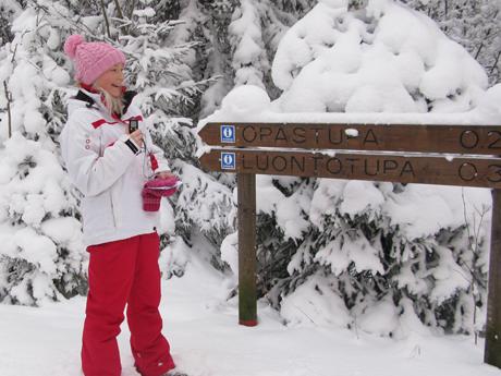
Figure 1. Seasonal conditions change the perception of the environment in nature.
We carried out an experimental study on route descriptions in the Nuuksio National Park with 20 participants. The participants were asked to describe by the thinking aloud method the surroundings of a route both in the summer and the winter. There were also asked to draw sketch maps of the route afterwards. Analysis of sentences and words in the route descriptions verified the importance of landmarks for spatial perception in nature. The results showed that landmarks were observed more frequently in the summer than in the winter. Seasonal differences were found in the use of landmark groups identified in the experiments.
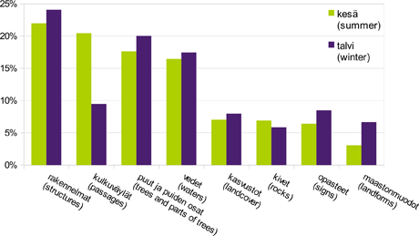
Figure 2. The use frequencies of landmark groups in the route description experiments in summer and winter.
Another topic in our research of spatial cognition has been the perception and conception of geospatial images that take various forms. Maps, aerial photographs, street views, and 3D renderings provide varying spatial knowledge of the viewed environment and support differently the formation of a cognitive map in human brain. We have used behavioural and eye-tracking measures in order to observe the effect of three-dimensional elements in maps, and plan further studies on the differences of geospatial images.
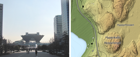
Figure 3. Different geospatial images provide varying spatial knowledge.
More about the topic:
Kettunen, P. and L. T. Sarjakoski, 2012. Näemmekö metsää puilta? (Eng. Do we recognize the forest over the trees?), Positio, (2/2012): 10–12.
Kettunen, P., Irvankoski, K., Krause, C. M., Sarjakoski, T. and L. T. Sarjakoski, 2012. Geospatial images in the acquisition of spatial knowledge for wayfinding. Journal of Spatial Information Science, 5:75-106. Online: http://dx.doi.org/10.5311/JOSIS.2012.5.85.
Sarjakoski, L. T., Kettunen, P., Flink, H.-M., Laakso, M., Rönneberg, M. and T. Sarjakoski, 2012. Analysis of verbal route descriptions and landmarks for hiking. Personal and Ubiquitous Computing, 16(8): 1001-1011. Online: http://dx.doi.org/10.1007/s00779-011-0460-7 (21/09/11).