Synthetic Aperture Radar (SAR)
SAR is an active remote sensing instrument (imaging radar) operating at the microwave part of the electro-magnetic radiation. One of the key benefits of SAR compared to lidars (or other instruments sensing visible or infra-red light) is its ability to acquire images through clouds being therefore an attractive sensor candidate for Earth Observation (EO) and environmental monitoring. We at the ActiveSensing-group are mainly interested in mapping of the land area in relation to novel SAR imaging techniques, to name but a few: PSI (Persistent Scatterers SAR Interferometry), radargrammetry, integrated use of radar and lidar data, and the utilization of the high geolocation accuracy of SAR satellite image data. In the past years, the research has been mainly carried out in outside funded projects and SAR data has been acquired through the scientific projects.
Some of the recent research projects are listed in the following:
- TanDEM-X Pre-Operational AO, 2011->, Estimation of forest variables at plot level from TanDEM-X data.
- Insect Combat, 2009-2010, Development of application prototype for the European Space Agency, DUE Innovators II - Insect Combat.
- TerraSAR-X Pre-Launch AO, 2009->, Feasibility Evaluation of TerraSAR-X in Agriculture, Forestry, Urban Mapping and Map Updating.
- Radarsat-2 SOAR projects (two), 2008-.
- ALOS PALSAR ADEN AO, 2008- , Use of ALOS PALSAR images in mapping, map updating, and forest inventories.
- NewSAR (in co-operation with VTT and TKK), 2007, Utilization Techniques for Polarimetric-Generation SAR Satellites, funded by TEKES.
- APPLISARIN, 2005-2006, Applications and software for SAR interferometry and coherent target monitoring (in co-operation with Pöyry Environment, Helsinki University of Technology, National Resources Canada, Canadian Forest Service, and Vexcel Canada Inc), funded by the Finnish Funding Agency for Technology and Innovation (TEKES).
- Applicability of Novel Very-High-Resolution SAR for Mapping, 2002-2004, funded by TEKES.
Some examples of results:
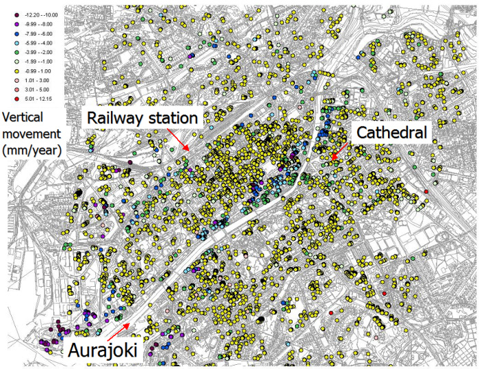
Result of the Permanent Scatterer Interferometry (PSI) analysis in Turku city (Original SAR data (c) ESA).
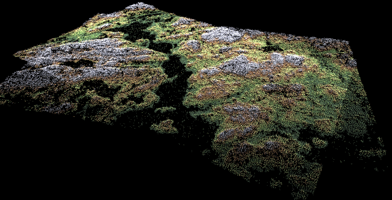
Elevation data extracted from TerraSAR-X stereo satellite images using the radargrammetry technique (Original SAR data (c) 2009, DLR).