All information associated with a location is geospatial data. Positioning and geospatial data are needed round the clock in the financial sector, power grids and land, sea and air transport. Smartphone applications and automotive navigation systems rely on satellite positioning.
In Finland, the Metsähovi geodetic research station is required to produce the most accurate positioning data. It ensures that global satellite positioning data are compatible with national geospatial data. As a result, the critical functions that require geospatial data run reliably.
- Geospatial data must be up to date to be reliable. The Earth and its surface are constantly moving, and the shapes of the Earth’s surface are changing. As a result, the Reference Frame which forms the foundation of geospatial data must be constantly monitored and updated, says Hannu Koivula, professor and director of the Department of Geodesy and Geodynamics at the Finnish Geospatial Research Institute (FGI) of the NLS.
Reliable positioning requires modern measuring equipment
The volume of and need for positioning data have increased dramatically. For Finland to continue to have the most accurate and reliable geospatial data available, it was necessary to update the measuring equipment in Metsähovi.
- Accurate positioning and the measurement and research of global changes require the most accurate geodetic data in the background. The satellite laser and geodetic VLBI measurements that are at their core have both undergone and are still undergoing a significant leap in both accuracy and the volume of the data needed. For the NLS to respond to these needs, it was necessary to update the Metsähovi measuring equipment and infrastructure to the 2020s, Koivula says.
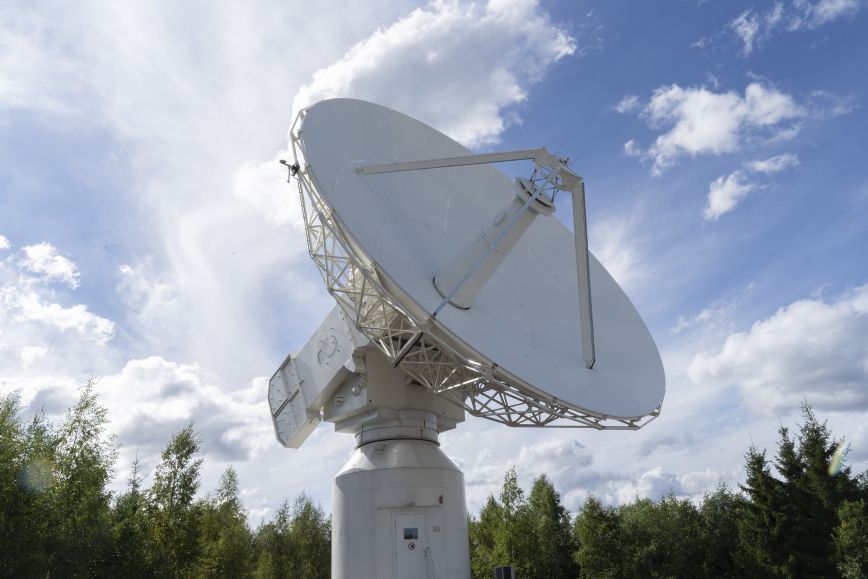
Updating the Metsähovi measuring infrastructure and equipment has been a massive project, during which the infrastructure and equipment was updated phase by phase. GNSS receivers and gravimeters have been updated to be top of the line, and they are already in operation. Now it is the turn of the SLR satellite laser and the VLBI radio telescope. The infrastructure update has received separate funding from the Ministry of Agriculture and Forestry. The completion of the separately funded phase was celebrated at Metsähovi’s grand opening on 30 August, with Antti Kurvinen, Minister of Agriculture and Forestry, being among the participants.
The updated Metsähovi equipment enables a more accurate assessment of climate change impact
Modern equipment produces more accurate geospatial data, even at an accuracy of millimetres. Accurate geodetic measuring data are critical in decision making when estimating the impact of climate change. How reliably we can monitor changes in the Arctic region and assess their impact on, say, sea level rise and our living conditions depends on the accuracy of satellite measurements. Having accurate and reliable geospatial data is also necessary for business based on such data, including smart transport, agriculture and forestry.
In addition to providing society with the geospatial data it needs, the Metsähovi geodetic research station’s other key responsibility is to conduct basic geodetic research, on which all geospatial data are ultimately based. Geodesy is a science to measure and understand the size and shape of the Earth, as well as the location of features on its surface.
- We provide the best possible scientific base for applications that benefit society by taking measuring accuracies and the quality and quantity of data to whole new heights. What increases Metsähovi’s importance is its unique location as the second northernmost geodetic base station in the world and the northernmost and easternmost station in the EU,’ Koivula says.
Geospatial data provided by the NLS also helps the UN
With other geodetic research stations across the world, Metsähovi’s observations produce the necessary measurements and coordinate systems to allow positioning satellites and Earth exploring satellites to function.
Metsähovi helps Finland fulfil its important role in the maintenance of the global geodetic reference frame, which is one of the UN’s Sustainable Development Goals. Finland was among the more than 50 other countries to present the related resolution to the UN General Assembly in 2015.
‘The Metsähovi geodetic research station is known globally for its key role in maintaining the global reference frame. The infrastructure update in Metsähovi helps advance the UN’s Sustainable Development Goals, as the global geodetic infrastructure requires significant updates to continue provide decision makers with accurate geospatial data,’ says Nicholas Brown, co-chair of the UN-GGIM Subcommittee on Geodesy.
Additional information
Hannu Koivula, professor, director, Department of Geodesy and Geodynamics, NLS, FGI
029 531 4787, +358 50 430 1639
Watch the introduction video of the Metsähovi geodetic research station