ActiveSensing-group has been active in ALS and TLS radiometric calibration studies in recent years. There is an increasing number of applications for laser scanning in environmental studies. Calibrated intensity could give added value for laser scanning campaigns, for example in making object recognition and classifying easier and more reliable for automatic tools.
There are still many challenges for radiometric calibration: detectors are not optimized for intensity (e.g., nonlinear amplifiers/reducers, automatic gain control,…) and available sensor information is very limited (on, e.g., pulse energy).
Radiometric calibration of airborne laser scanners (ALS)
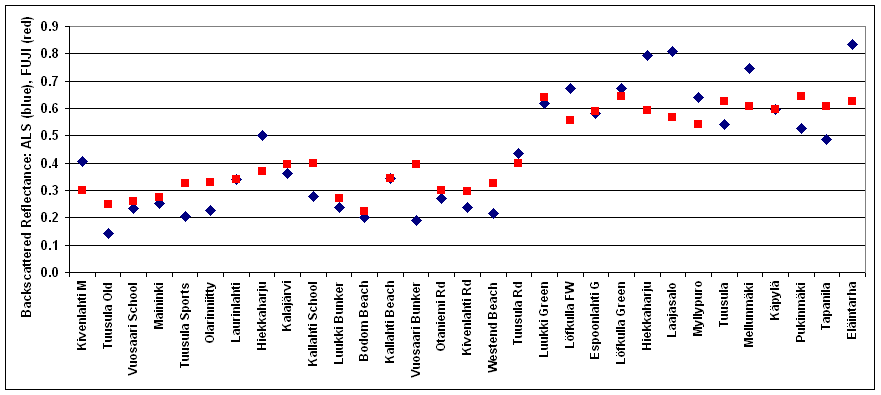
Comparison of backscattered reflectance between ALS data and NIR digital camera. Colums on the left are sand (e.g., sand fields, beaches and roads), columns on the right, starting from Luukki Green, are grass (e.g., golf greens and fairways and football fields).
In our most recent study, we studied a large bulk of land targets with the NIR digital camera and compared the reflectance data with ALS intensity data (data from the National Land Survey). The calibration of ALS intensity data with these reference targets improves the accuracy and compatibility of separate intensity data sets (data from 3 different flights were studied). We also studied the feasibility of separating different types of targets, namely sand and grass (sand fields and beaches, golf greens and fairways, football fields, etc.). Only calibrated data produced probability levels of the same mean (for targets of the same target class) that were high enough for classification.
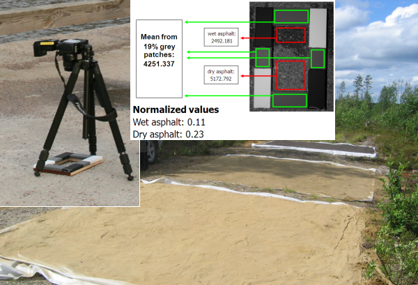
The FGI calibration concept for laser scanner intensity is based on external in situ reference targets, such as portable brightness tarps, commercially or naturally available sand & gravel and laboratory/field calibration for reflectance (grey)scale. The use of "manmade natural" targets, i.e. sports fields, tennis courts, golf courses, sand roads, natural beaches etc., is also studied. A modified digital camera together with a calibration frame can be used to collect in situ reference.
The near-infrared digital camera based reference measurement is operational and used, in, e.g., Hyytiälä/Evo airborne laser scanning campaign (by the University of Helsinki, Department of Forest Sciences) in July 2010.
Radiometric calibration of terrestrial laser scanners (TLS)
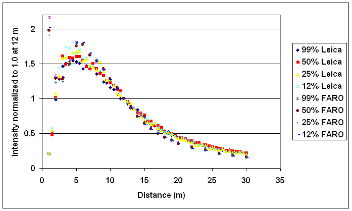
Intensity vs. range for FARO LS880 and Leica HDS 6100 terrestrial laser scanners for a 4-step Spectralon brightness target.
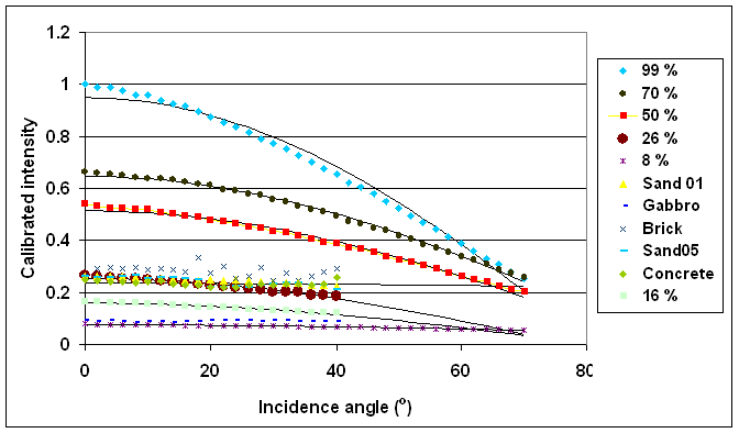
The effect of incidence angle on the intensity measured with the FARO LS880 terrestrial laser scanner. A correction function has been fitted to the data. See http://www.mdpi.com/2072-4292/3/10/2207/ for more information.