Would you like to focus the map on a specific place or find a map layer for a specific purpose in Paikkatietoikkuna? You can search for places and spatial data by using the Search tool.
Return to Instructions of Paikkatietoikkuna -website.
Location search
Using the Location search, you can search for places. Enter your search term in the search field and click the ‘Search’ button. The search term can be:
- a place name
- an address
- a property identifier
- a TM35 map sheet identifier
You can cut the search term by entering the asterisk (*) at the end of the search term. For example, if you type ‘Hels*’, the search results will include all place names and addresses starting with ‘Hels’. The search term must always include at least one other character in addition to the asterisk. The number of asterisks or their place in the search term is not limited. For example, if you type ‘puo**la’, the search results will include such places as ‘Puomila’ and ‘Puotila’.
When you type your search term, the service will give you suggestions based on similar searches. Click a suggested search term to carry out a search using that search term. This makes it easier to search for place names in the Sámi language, for example, as you do not need to use any special characters. For example, the search term ‘Cevet’ will offer such suggestions as ‘Čevetjävri’.
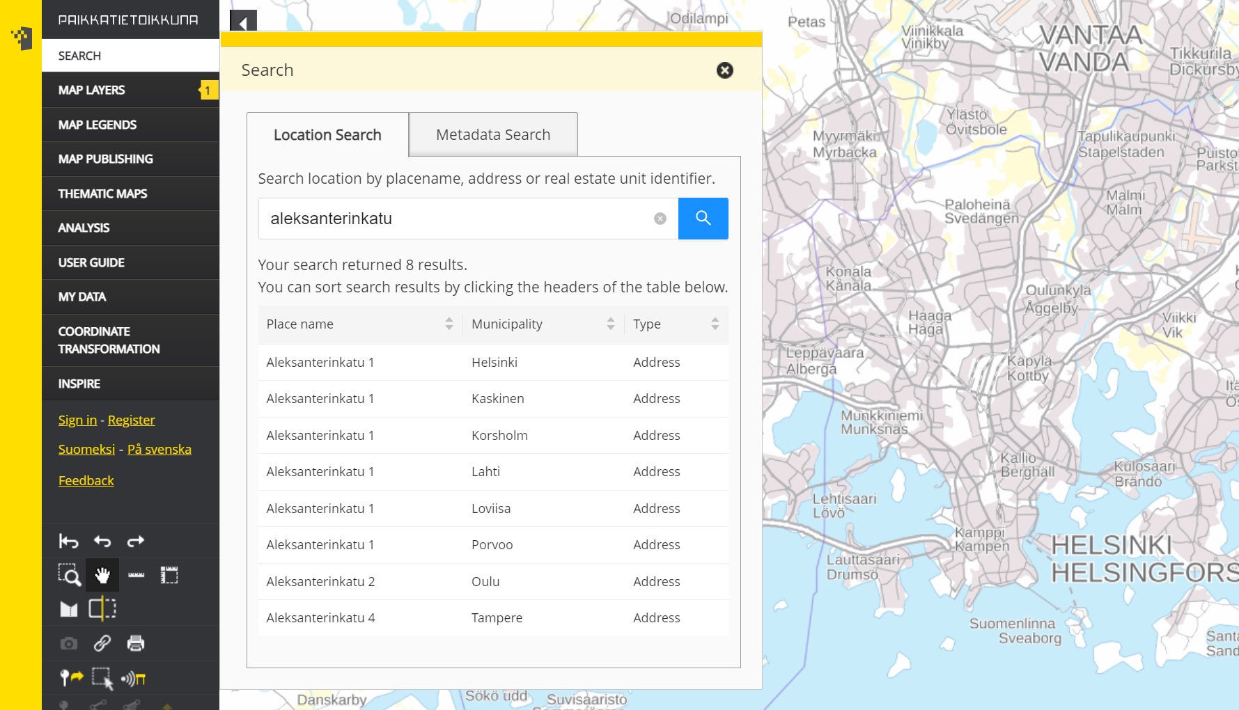
The address search results only show the smallest street number (usually ‘1’) in each municipality. For example, the search term ‘Porvoonkatu’ will produce three results: ‘Porvoonkatu 1, Helsinki’, ‘Porvoonkatu 1, Kerava’ and ‘Porvoonkatu 6, Loviisa’. The image presents a similar example using the search term ‘aleksanterinkatu’.
The property identifier must be accurate and in format ‘611-401-3-43’. The results include all parcels of the property in question. Click a parcel to view its location on the map. Different parcels of a single property may be far apart.
The map sheet identifier is in format ‘L4133B’, for example. Using the search term ‘L4’, you will only receive results matching your search term: map sheet L4 and its centre point marked on a map.
Metadata search
The Metadata search tool allows you to search för metadata regarding spatial data resources, datasets, dataset series and services stored in The Geospatial Metadata Catalogue Paikkatietohakemisto.
Type a search word in the search field. The search is done in the Spatial Data Catalogue and targets dataset name, data provider and keywords.
Characters allowed in the search words are letters (a–ö, A–Ö), numbers (0–9), period (.), comma (,), hyphen (-) and exclamation mark (!). You can replace one character in the search term with a question mark (?) and the entire end of a search term with an asterisk (*). Note that if you use an asterisk, the search term must contain at least four other characters.

Click the Search icon to get the search results.

- You can narrow down the search results by clicking on "Show all search results"
- "Show only datasets" filters the search results to geospatial datasets, that is the data itself.
- "Show only services" filters the search results to geospatial services, that is the interfaces through which the data is accessed
- You can display the dataset using the toggle, if it is available as a map layer in Paikkatietoikkuna.
- Click the blue [?] button to view the coverage area of the dataset on the map.
- To view the metadata, click the name of the dataset or service.
- On the ISO 19115 Metadata tab, the descriptions follow the JHS 158 recommendation, “Metadata for geographic information.”
- On the INSPIRE Metadata tab, the metadata complies with the INSPIRE Directive.
- The Data quality section provides details about the dataset’s background, history, and compliance.
- On the Actions tab, you can open the metadata as an XML file.
- Return to the search by clicking “Edit search options.”

Questions or comments? Contact Paikkatietoikkuna's support: Contact us | National Land Survey.