This page contains important information about parameters and grid files needed for coordinate transformations.
Coordinate transformations are open-source data. The methods and parameters used for the transformations can be downloaded free of charge. The files are subject to the open-source data license of the National Land Survey of Finland (CC 4.0 Attribution)
Please use the following citation for the FIN2023N2000 model:
Saari, T., Bilker-Koivula, M., & Häkli, P. 2024. FIN2023N2000 geoid model. National Land Survey of Finland, FGI Dept. of Geodesy and geodynamics. https://doi.org/10.23729/a82f4cd8-fe16-4843-8f41-95ef9abc3ff8
Height transformations between EUREF-FIN and N2000
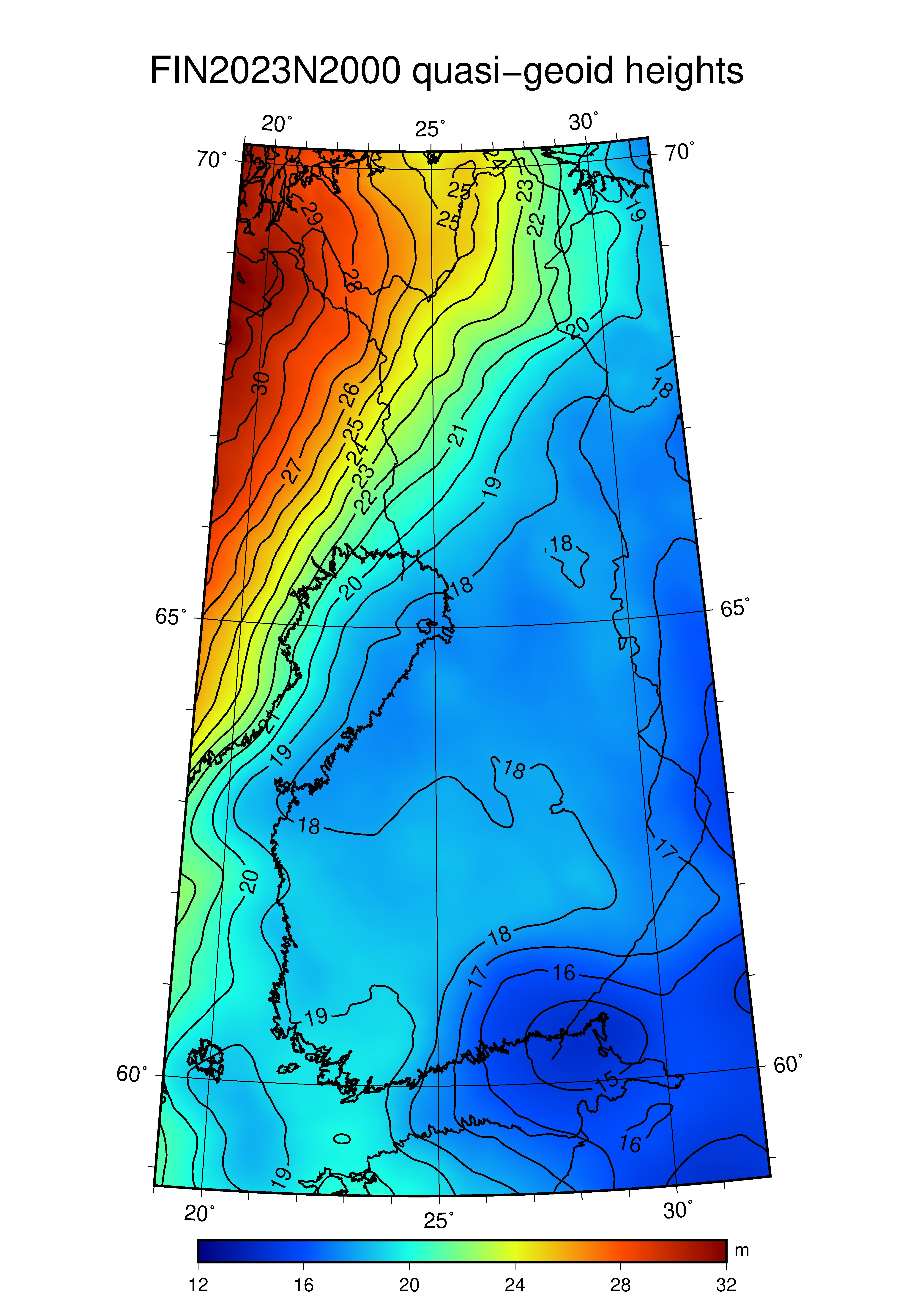
The FIN2023N2000 is a quasigeoid model (height conversion surface) of Finland. The model is recommended to be used inside of the Finnish borders as well as in the territorial waters of Finland. The model contains quasigeoid heights, ζ, that are used to convert EUREF-FIN ellipsoidal heights, h, to normal heights, H*, in the national height system of Finland, N2000.
Quasigeoid heights in the FIN2023N2000-model are given in meters with millimeter accuracy. Evaluating the model with the ground truth in Finland (first order GPS-levelling dataset), an accuracy of ±1.38 cm was achieved nationwide. The largest quasigeoid height differences between the FIN2023N2000-model and GPS-levelling are 3–4 cm.
To transform heights between the systems, one must first find the four points from the geoid grid that are nearest to the geographical EUREF-FIN coordinates of the point that is to be transformed. I.e., which four points close the point in question inside of a rectangle. Next, quasigeoid height of the transformed point is calculated with bilinear interpolation using the four grid points. Finally, normal height is calculated by deducting the quasigeoid height from the EUREF-FIN ellipsoidal height (H* = h - ζ).
The FIN2023N2000 is available in three ASCII-formats (box, grid and list). The dimensions of the model with grid spacings are given in the first row (header) of the box and grid -files. Values of latitudes and longitudes are given in degrees. Dimensions are the following:
| Attribute | Value |
|---|---|
| Minimum latitude | 58.80° |
| Maximum latitude | 70.19° |
| Minimum longitude | 19.00° |
| Maximum longitude | 31.98° |
| Latitude spacing | 0.01° |
| Longitude spacing | 0.02° |
| Total number of points | 741 000 |
Scientific article from the creation of the FIN2023N2000-model is under preparation. A link to the article will be provided in 2024.
Box-format
After the header, the quasigeoid heights for each grid point are given as following:
- The heights are given row-wise from north to south, starting in the northwest and ending in the southeast
- The first row corresponds to latitude 70.19° and the last row corresponds to latitude 58.80°
- The first height in a row has longitude 19.00° and the last height has longitude 31.98°
- Number of rows: (70.19 - 58.80) / 0.01 + 1 = 1140
- Number of columns: (31.98 - 19.00) / 0.02 + 1 = 650
- Total number of heights: 1140 * 650 = 741 000
- Heights are given in meters with millimeter accuracy.
Download files:
Grid-format
After the header, the quasigeoid heights for each grid point are given as following:
- The first 650 values ((31.98 - 19.00) / 0.02 + 1 = 650) are the heights of the northernmost latitude (70.19°). The values of a single latitude consists of two (30 rows * 8 columns) and one (21 rows * 8 columns + 1 row * 2 columns) grids: (30 + 30 + 21) * 8 + 2 = 650.
- The next 650 values are the heights of the second northernmost latitude (70.18°), etc.
- Total number of heights: 1140 * 650 = 741 000
- Heights are given in meters with millimeter accuracy.
Download files:
List-format
The file consist of rows, which are given as following (file starts from the northwest and ends in the southeast):
- Latitude, longitude and quasigeoid height
- Latitudes and longitudes are given in degrees
- Heights are given in meters with millimeter accuracy.
Download files: