You can search for news in the newsroom by selecting the news type (news, article, blog), filtering keywords according to theme or typing a search term in the search term field.
Search in newsroom
-
 Read more about Mobile laser scanning superior to conventional methods
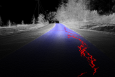
Mobile laser scanning superior to conventional methods
Research conducted at the Finnish Geospatial Research Institute (FGI) of the National Land Survey of Finland (NLS) has given promising results of the use of a mobile laser scanner to analyse road conditions
Press releaseResearchLaser scanning -
 Read more about Housing companies will start entering renovation information into the Residential and Commercial Property Information System
Housing companies will start entering renovation information into the Residential and Commercial Property Information System
In June this year, property managers will have the opportunity to enter information concerning maintenance and renovation work in housing companies in the Residential and Commercial Property Information System.
-
 Read more about Not everyone owns their holiday home’s shoreline − land rises a centimetre a year in Vaasa
Not everyone owns their holiday home’s shoreline − land rises a centimetre a year in Vaasa
Currently, not everyone owns the shoreline of their plot by the sea, and they may not even know it.
-
 Read more about Nummela in Finland is home to the world’s most accurate line
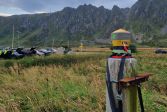
Nummela in Finland is home to the world’s most accurate line
The Nummela Standard Baseline is the world’s most accurate distance measurable between two points in the terrain, which attracts industrial customers, researchers and representatives of land survey organisations from across the world.
ResearchFinnish Geospatial Research Institute (FGI)Press release -
 Read more about Changes in the National Land Survey of Finland’s prices from 1 January 2025
Changes in the National Land Survey of Finland’s prices from 1 January 2025
The National Land Survey of Finland (NLS) will change its pricing from 1 January 2025. The price changes are based on the increase in general cost levels.
NLSCustomer ServiceServices -
 Read more about Geoportti added to the roadmap for Finnish research infrastructures 2025–2028
Geoportti added to the roadmap for Finnish research infrastructures 2025–2028
Geoportti services promote Finland’s RDI goals by, for example, providing open easy-to-use geospatial datasets and high-performance computing services for researchers, decision-makers and companies to accelerate research, development and innovation.
Finnish Geospatial Research Institute (FGI)Spatial dataResearch -
 Read more about The NLS exposed its equipment to GNSS interference in the Jammertest event so that researchers can develop solutions against it
The NLS exposed its equipment to GNSS interference in the Jammertest event so that researchers can develop solutions against it
How does GNSS interference affect the operation of the National Land Survey of Finland (NLS)?
Finnish Geospatial Research Institute (FGI)ResearchPress release -
 Read more about Sales of printed maps to end – check the opportunities offered by electronic maps
Sales of printed maps to end – check the opportunities offered by electronic maps
While the National Land Survey of Finland (NLS) will stop selling printed maps by the end of 2024, our broad range of maps will continue to be available to everyone online and as map printouts.
MapsTopographic mapServices -
 Read more about On a diversity journey
On a diversity journey
While non-discrimination has for long been part of the National Land Survey of Finland’s (NLS) personnel plan and management principles, our actual diversity journey started in 2022.
Sustainability -
 Read more about The national aerial photography and laser scanning programme saves millions for society
The national aerial photography and laser scanning programme saves millions for society
In the future, even more accurate data may be available.
ResearchPress releaseLaser scanning
More information
Searching for Service messages?
Service messages are published under Our online services. There you can also check the availability of applications and services.