News and articles
-
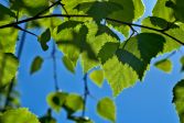 Read more about Researchers discover that trees awaken to spring at their own pace, even within the same species in the same forest
Researchers discover that trees awaken to spring at their own pace, even within the same species in the same forest
A study by the National Land Survey of Finland and the University of Helsinki has revealed significant individual differences in how trees awaken for the growing season.
Press releaseFinnish Geospatial Research Institute (FGI)Research -
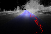
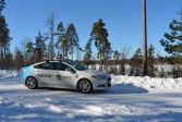 Read more about An autonomous car driving on the streets helps cities solve problems of the future
An autonomous car driving on the streets helps cities solve problems of the future
The Finnish Geospatial Research Institute’s self-driving car collects accurate data on its surroundings while driving on the streets of cities regarding, for example, the road conditions, carbon sinks in trees, and any needs to prepare for floods.
ResearchFinnish Geospatial Research Institute (FGI)Press release -
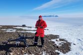 Read more about Unusual anomaly in Antarctic glaciers
Unusual anomaly in Antarctic glaciers
Researchers of the National Land Survey of Finland’s Geospatial Research Institute and the Finnish Meteorological Institute have found that as Antarctic glaciers continue to melt, the thickness of the ice at Finland’s research station is growing.
Press releaseResearchLaser scanning -
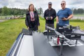 Read more about Finland has the potential of becoming a drone technology superpower
Finland has the potential of becoming a drone technology superpower
Eija Honkavaara, a pioneer in drone research, sees that Finland has all the prerequisites for success in drone technology, as long as the path from research results into business is in order.
Press releaseResearchFinnish Geospatial Research Institute (FGI) -
 Read more about Research by the NLS produced millions in benefits for society in 2024
Research by the NLS produced millions in benefits for society in 2024
Preparation for interference with satellite positioning, information about the state of the environment collected using drones, and observing the planet using satellites are a few of the research themes.
Press releaseResearchFinnish Geospatial Research Institute (FGI) -
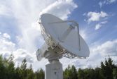
 Read more about 30-years of Finland in ESA
30-years of Finland in ESA
Earth Observation growing strong in Finland with Arctic Satellite Calibration and Validation Center and new space opportunities
ResearchFinnish Geospatial Research Institute (FGI)Press release -
 Read more about New goals and metrics guide the NLS’s sustainability activities
New goals and metrics guide the NLS’s sustainability activities
The National Land Survey of Finland has updated its sustainability programme and goals for 2025–2030.
Sustainability -
 Read more about Mobile laser scanning superior to conventional methods
Mobile laser scanning superior to conventional methods
Research conducted at the Finnish Geospatial Research Institute (FGI) of the National Land Survey of Finland (NLS) has given promising results of the use of a mobile laser scanner to analyse road conditions
Press releaseResearchLaser scanning -
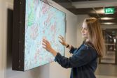
 Read more about Housing companies will start entering renovation information into the Residential and Commercial Property Information System
Housing companies will start entering renovation information into the Residential and Commercial Property Information System
In June this year, property managers will have the opportunity to enter information concerning maintenance and renovation work in housing companies in the Residential and Commercial Property Information System.
-
 Read more about Not everyone owns their holiday home’s shoreline − land rises a centimetre a year in Vaasa
Not everyone owns their holiday home’s shoreline − land rises a centimetre a year in Vaasa
Currently, not everyone owns the shoreline of their plot by the sea, and they may not even know it.
More information
For media
Our Communication Services assist media representatives in finding needed information, photographs and experts.