Laser scanning data 5 p
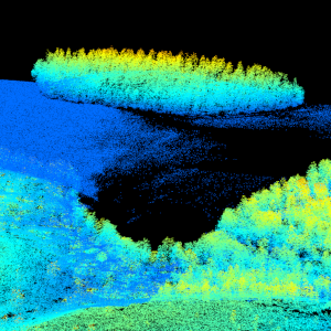
Laser scanning data refers to three-dimensional point-like data depicting the ground and objects on the ground. Each point is provided with x, y and z coordinate information.
Laser scanning data is collected i.a. for updating elevation models, creating 3D geometries of buildings, mapping flood risks, and collecting information about forest resources.
The terms of use must be approved to use laser scanning data.
Purpose:
Laser scanning data is utilised i.a. for making topographic models. Topographic models are used in route optimisation and data collection applications and in applications studying water discharge and the forms of the ground surface.
Laser scanning data and three-dimensional models derived from it are applicable to be used in depicting the urban environment, e.g. in noise modelling. Laser scanning data is also utilised in land use planning and collecting information about forest resources and also in other analysis and monitoring of changes in the natural environment.
Geographic location
Entire Finland
Reference system
ETRS89 / TM35FIN(E,N) (EPSG:3067)
N2000 height (EPSG:3900)
Pixel size
5 p/m²
Spatial representation
Vector
Data content
Laser scanning data 5 p/m²
The product includes map sheets that fall entirely within the production area (partially at the national frontier) and have been laser scanned entirely.
Laser scanning data 5 p has been quality checked and processed as well as possible to form the foundation for the nationwide elevation model and to be suitable for the needs of the nationwide forest classification. The classifications of point clouds have been implemented as automatic classifications. The classifications of air points or error points mentioned below have mainly been done automatically, and in practice they are never fully comprehensive. Other users of the data can filter and classify the data according to their own needs.
The point density (pulse density, i.e. outgoing laser pulses per square metre) is comprehensively at least 5 points/m², i.e. the distance between laser points on the ground is on average no more than approx. 0.40 m. The distribution of points (scanning image) is not necessarily completely even, but it depends on the type of scanner and the settings of each scanning flight.
Point classes:
Unclassified (class value 1 according to LAS format, Unclassified). Before classification, all the laser points are in this class. After classification, this class includes all the points whose class has not changed in the classification process.
Overlap area (class value 12 according to LAS format, Overlap). In case of overlapping trajectories, further classification only includes points from one trajectory. The rest of the points are included in this class. These points used for combining trajectories have been deleted from the data to lighten the data load, but they have been stored for possible exceptional needs.
Isolated, class value 16. Single points in the air and below ground level are classified in the Isolated class to decrease error points. A point is classified in this class, if there are 10 or fewer other points within a radius of 5 metres from the point. Some laser points from real features, such as points from power lines, or tree trunks in an open forest, are also included in this class.
Low error points (class value 7 according to LAS format, Low Point). These points are according to the automatic classification statistically too low compared to the points in their surroundings. They can be due to e.g. scanner faults, multiple reflections of the laser pulse, or an incorrect separation of the return echo in the scanning system.
Ground (class value 2 according to LAS format, Ground). These points represent the lowest surface that can be perceived from the air. The result depends on the values chosen for the parameters of the classification algorithm, and it is always a compromise between the number of points not belonging to the surface of the ground and points that the surface of the ground is lacking.
Air points, class value 15. Clouds, flying objects or other objects in the air are classified in this class.
Fault points, class value 17. Points due to scanner faults, remaining after automatic classifications are classified in this class.
Remaining unclassified (default class) laser points are classified according to elevation level in relation to the surface of the ground in three stages. The points include more than just vegetation points, even if the name of the class refers to vegetation.
Low vegetation (class value 3 according to LAS format, Low Vegetation). Laser points from the height of 0.0–0.5 metres above ground level are classified in class 3.
Medium vegetation (class value 4 according to LAS format, Medium Vegetation). Laser points from the height of 0.5–2.0 metres above ground level are classified in class 4.
High vegetation (class value 5 according to LAS format, High Vegetation). Laser points from the height of 2.0–50.0 metres above ground level are classified in class 5.
The distribution format for data gathered in 2020-2023 is LAZ 1.2 and LAZ 1.4 for data gathered 2024 and onwards.
The material with limited distribution has been processed into blocks of 1 x 1 km (1/9 of a UTM 5000 map sheet).
Maintenance
Maintenance
The product is updated annually according to the national laser scanning programme: https://www.maanmittauslaitos.fi/laserkeilaus-ja-ilmakuvaus. The product is available by production area. Some production areas may include supplementary data that has been laser scanned afterwards.
The progress of the scanning and the availability of products can be seen on the status map: https://tilannekartta.maanmittauslaitos.fi/laserkeilaus
Quality information
Lineage
The product Laser scanning data 5 p is the National Land Survey’s most accurate elevation data set. The point density of the data is at minimum 5 points per square metre (the distance between the points on the ground is approx. 0.4 metres). Regarding unambiguous objects, the standard error of the elevation accuracy is at maximum 10 centimetres and the standard error in planimetric accuracy 45 centimetres.
This dataset is at the latest available for each laser scanning production area by the end of that year when the scanning of the area has been performed.
Distribution and further information
Responsible party
National Land Survey of Finland
Conditions applying to access and use
The terms of use must be approved to use laser scanning data. Licence information (Finnish): https://www.maanmittauslaitos.fi/laserkeilausaineistot/kayttoehdot
Distribution format
LAZ
Distribution channels
Pricing
Laser scanning data 5 p from e-services - MapSite and e-services
| Product | Price € (excl. VAT) | Price € (incl. VAT) |
|---|---|---|
| 77103010026 Laser scanning data 5 p, licence and data detachment per km2 | €0,026 | €0,033 |
| 77103010025 Laser scanning data 5 p, licence and data detachment, minimun fee | €26,69 | €33,50 |
Not based on a decree