Elevation zones (raster)
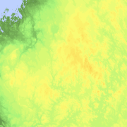
Elevation zones is a raster dataset that visualises elevation of the terrain. The product covers the whole of Finland. There are four product versions available in which the pixel sizes are 32, 64, 128 and 512 metres. The dataset does not contain elevation values; it is a colour image that visualises the height of the terrain above sea level as zones. The sea is shown in light blue in the elevation zone. The product Elevation zones is available as a version that covers the whole country and as versions that cover a certain area.
The product belongs to the open data of the National Land Survey of Finland.
Purpose:
The dataset Elevation zones can be used as a background map material to visualise the topography of the terrain (height above sea level).
Geographic location
Entire Finland
Reference system
ETRS89 / TM35FIN(E,N) (EPSG:3067)
N2000 height (EPSG:3900)
Pixel size
32 m
64 m
128 m
512 m
Spatial representation
Raster
Portrayal catalogue citation
The portrayal catalogue of Elevation zones is available at (in Finnish):
Data content
Versions of the dataset Elevation zones:
Elevation zone pixel size 32 m
Elevation zone pixel size 64 m
Elevation zone pixel size 128 m
Elevation zone pixel size 512 m
In pixel sizes from 32 metres to 128 metres the elevation of the terrain is divided into 30 elevation classes and in pixel size 512 metres into 16 classes.
Maintenance
Maintenance
All rasters have been updated in October 2015.
The Elevation zones (raster) product is based on the Elevation model 10 m product, which in turn consists of the data in Elevation model 2 m. If there are changes in the source data, the Elevation zones product is updated in the services once a month (see Distribution and further information).
Quality information
Lineage
Elevation zones is produced from Elevation model 10 m.
Distribution and further information
Responsible party
National Land Survey of Finland
Conditions applying to access and use
Mention the name of the Licensor (the National Land Survey of Finland), the name of the dataset(s) and the time when the National Land Survey has delivered the dataset(s) (e.g.: contains data from the National Land Survey of Finland Topographic Database 06/2014).
Distribution format
GeoTIFF
Distribution channels
Further information
The 512 m pixel version can be downloaded as an image covering the whole of Finland. Other versions can be downloaded by map sheet.
Pricing
Not based on a decree