You can search for news in the newsroom by selecting the news type (news, article, blog), filtering keywords according to theme or typing a search term in the search term field.
Search in newsroom
-
 Read more about Location can also be positioned without a satellite signal
Location can also be positioned without a satellite signal
There is a great need for positioning free from interference in satellite positioning. The dissertation of researcher Maija Mäkelä, presents a cooperative approach that does not need a satellite signal at all.
ResearchPositioningFinnish Geospatial Research Institute (FGI) -
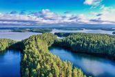
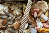 Read more about Find the best berry and mushroom spots with maps and aerial images
Find the best berry and mushroom spots with maps and aerial images
The maps produced by the National Land Survey of Finland (NLS) and related geospatial data services such as the MapSite provide comprehensive information about Finland’s terrain and forests. These free, open-access online services can also be used to plan berry-picking and mushrooming trips.
MapsSpatial dataPress release -
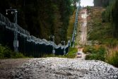 Read more about The first compensations for the eastern border barrier fence to be paid soon
The first compensations for the eastern border barrier fence to be paid soon
Several sections of the 200-kilometre-long barrier fence along the eastern border will be completed during 2025. The expropriation committee, led by a cadastral surveyor from the National Land Survey of Finland, assesses and determines the expropriation compensation for landowners at a new increased rate.
Press releaseExpropriation surveySurveying -
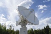 Read more about The UN urges member states to safeguard observations important for positioning
The UN urges member states to safeguard observations important for positioning
Many activities critical to society, such as rescue services, power grids and stock exchanges, require satellite positioning to function properly.
ResearchFinnish Geospatial Research Institute (FGI)Press release -
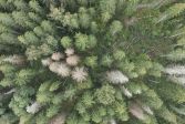 Read more about Drones are used to detect spruce bark beetle’s damage to trees faster than before
Drones are used to detect spruce bark beetle’s damage to trees faster than before
Researchers at the National Land Survey of Finland have developed an artificial intelligence method that helps detect the early signs of damage faster.
Press releaseResearchFinnish Geospatial Research Institute (FGI) -
 Read more about Use geospatial data to enrich your hiking experience
Use geospatial data to enrich your hiking experience
In Paikkatietoikkuna sercive, you can plan your upcoming hikes by saving hiking or jogging trails.
Spatial dataMapsPress release -
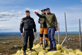 Read more about The review of the state boundary between Finland and Norway is nearing completion – the final inspection of terrain work is complete
The review of the state boundary between Finland and Norway is nearing completion – the final inspection of terrain work is complete
The Finnish and Norwegian border commissions completed the final inspection of terrain work on the national border between Finland and Norway in June.
MapsSpatial dataSurveying -
 Read more about How strong is gravity in Lapland and do you know what it affects?
How strong is gravity in Lapland and do you know what it affects?
Finland’s gravity is in constant motion which is why researchers from the Finnish Geospatial Research Institute (FGI) of the National Land Survey of Finland (NLS) measure it every year.
ResearchFinnish Geospatial Research Institute (FGI)Press release -
 Read more about What does the future of location-based services look like? Three points
What does the future of location-based services look like? Three points
Location Based Services 2025 (LBS2025) provided insights into what is happening in the growing field and what kind of opportunities the development will bring.
ResearchFinnish Geospatial Research Institute (FGI) -
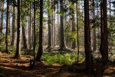 Read more about Data on individual trees to become available in the forest sector
Data on individual trees to become available in the forest sector
The NLS and the Finnish Forest Centre have started a joint research project to diversify and specify data on forest resources at the level of individual trees. In the coming years, data on forest changes and biodiversity will be required to monitor EU obligations, among other uses.
Press releaseResearchLaser scanning
More information
Searching for Service messages?
Service messages are published under Our online services. There you can also check the availability of applications and services.