
The Land Information System is a nationwide basic register that safeguards land ownership and contains information about each property in Finland. A property means a land or water area such as a plot of land.
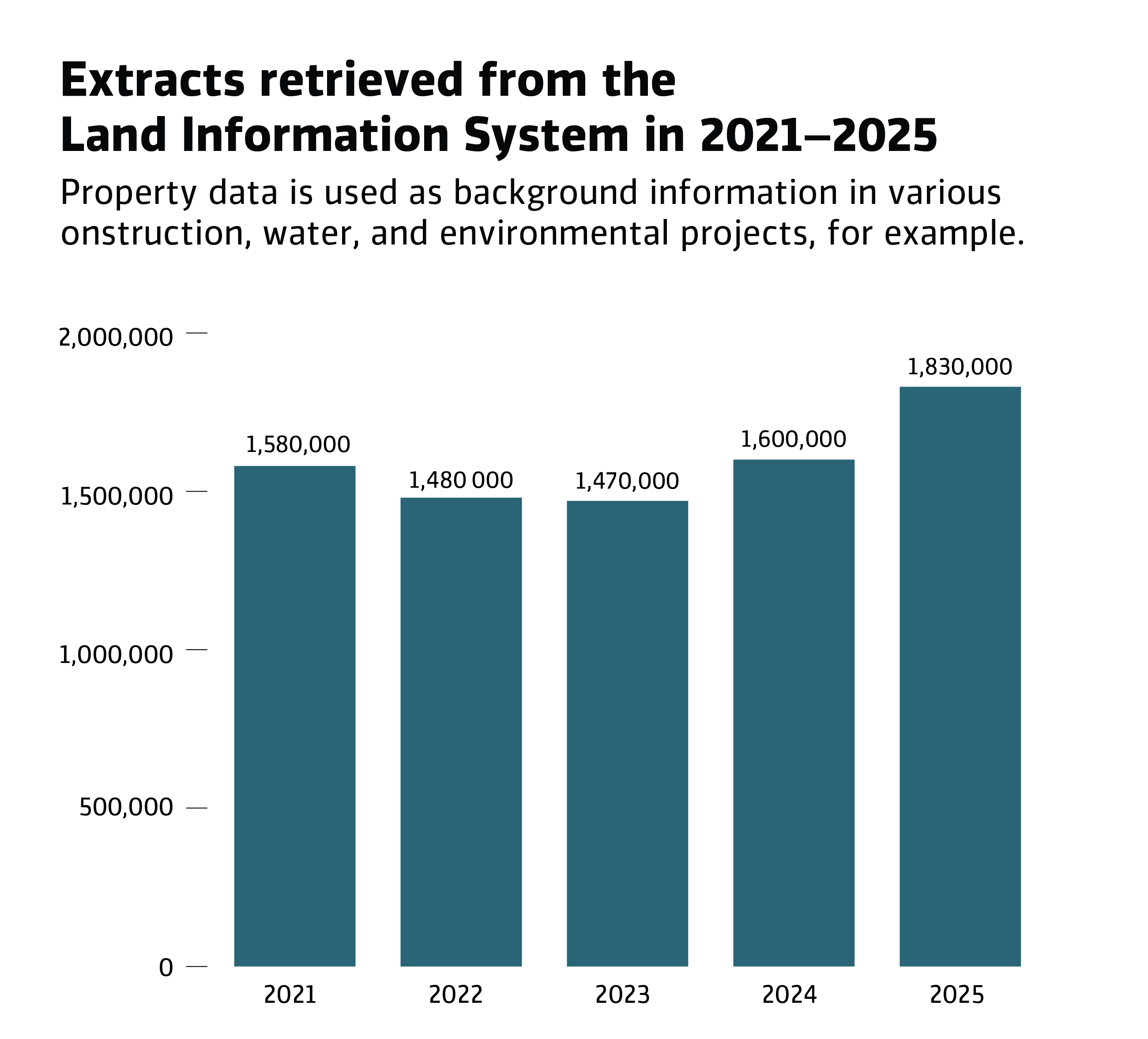
In 2025, 1.83 million extracts were retrieved from the Land Information System, marking an increase of 230,000 from the previous year. The cadastral register received 300 million digital queries, while the corresponding figure for 2024 was 211 million. The number of queries therefore increased by 89 million within a year.
– “The growth is explained by the EU-wide Sustainable Finance Disclosure Regulation, which directs banks to maintain increasingly detailed information about collateral items,” says Service Manager Teija Tarvainen.
Large projects such as the construction of transport connections also contribute to the increase in the query volumes of property data. For example, various construction, water and environmental projects require data about landowners as background information.
Land ownership is based on the Land Information System
The Land Information System contains the data of 2.85 million Finnish properties.
– “The most commonly used information in the Land Information System includes details about property ownership and management, property features, dimensions and rights, property transfer data, as well as information about private roads and road associations,” Tarvainen explains.
For example, the Land Information System enables the buyer of a property to acquire information about what exactly the transaction involves, where the boundary markers are located, and whether there are rights or restrictions related to the property. These may include the right of others to pass through the area to a boat shore near the property or a neighbour’s right to build a well on the land. The Land Information System also enables the use of a property as collateral for loans.
Property data serves as a basis for business
The main users of the Land Information System are central government, municipalities, retailers, the forestry and energy sectors, the banking sector and urban planning.
Retailers provide land management information to their own customers through user interfaces and interface services.
– “Through retailers, private sector companies also receive extensive information from other authorities and stakeholders, and it is precisely the integration of this data that enables companies to develop their business,” says Tarvainen.
Forestry and energy companies use property data extensively to support their operations, utilising the data in forest asset management and planning, wood trade, logistics, and environmental and sustainability reporting. When forestry companies purchase wood, they must ensure that the seller has the legal right to sell the wood.
Energy companies, on the other hand, use property information in the planning and construction of electricity and district heating networks, in verifying ownership details and in permit processes.
– “Property information is also essential in planning maintenance work, as well as in disruptions and communicating about them,” Tarvainen continues.
Banks operating in the financial sector use property data especially in collateral management, credit granting and risk management. Banks also use property data to monitor property transactions and review contracts and documents.
Property data should be developed for cybersecurity foresight
The maintenance of property data requires development, as the requirements are constantly growing. Increased regulation and cybersecurity pose challenges.
While many things change, one that remains the same is the fact that a significant part of Finnish wealth is tied up in properties. Indeed, the Land Information System will also be of great importance to Finnish society in the future: a disruption in the operation of the system would cause extensive economic damage to several sectors of society, as a recent study shows.
The National Land Survey of Finland is preparing to launch a property information development project.
The responsibility for the Land Information System lies with the NLS and 67 municipalities.
Further information
Teija Tarvainen, service manager, Information services, p. +358 29 531 5066, firstname.lastname@maanmittauslaitos.fi
Jani Hokkanen, director, Information services, p. +358 29 531 5612, firstname.lastname@maanmittauslaitos.fi