News and articles
-
 Read more about Gummy bears help identify foreign grains
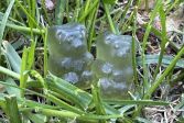
Gummy bears help identify foreign grains
The National Land Survey of Finland’s Geospatial Research Institute (FGI) is involved in developing a new digital solution for identifying and removing foreign grains from fields.
Press releaseResearchFinnish Geospatial Research Institute (FGI) -
 Read more about Satellite positioning researchers will meet in Finland to solve positioning challenges
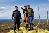
Satellite positioning researchers will meet in Finland to solve positioning challenges
In July, the European Space Agency and the European Commission's Joint Research Centre are holding an international research event on satellite positioning in Finland.
ResearchFinnish Geospatial Research Institute (FGI)Press release -
 Read more about Uncleared estates complicate the management of property matters
Uncleared estates complicate the management of property matters
When the owner of a property dies, the heirs should apply for a clarification of ownership, i.e. clarification of the title. In Finland, there are 230,000 properties without a clarification of ownership.
Real propertyServicesPress release -
 Read more about Procurement decision made in the joint IT Framework Agreement of the Ministry of Agriculture and Forestry
Procurement decision made in the joint IT Framework Agreement of the Ministry of Agriculture and Forestry
The joint procurement includes IT expert tasks related to the development and maintenance of information systems, applications, and platforms, as well as expert tasks related to cloud services, architecture, and quality assurance.
Press releaseDigitalizationNLS -
 Read more about No significant changes on the Norway–Finland border
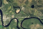
No significant changes on the Norway–Finland border
The Finnish and Norwegian border commissions have reviewed the 737‑kilometre state boundary. In connection with the review, the boundary was measured, and all 209 border markers were checked, maintained, and documented.
Press releaseMapsSpatial data -
 Read more about Can Low-Earth-Orbit satellites improve positioning resilience against GNSS jamming?
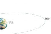
Can Low-Earth-Orbit satellites improve positioning resilience against GNSS jamming?
Researchers from the Finnish Geospatial Research Institute (FGI) are contributing to the Celeste project by evaluating the performance of the Celeste IOD signals in the Arctic region.
ResearchFinnish Geospatial Research Institute (FGI)Press release -
 Read more about Use of property data increased by 16% in 2025
Use of property data increased by 16% in 2025
The use of property data produced by the National Land Survey of Finland (NLS) increased by more than 16% in 2025 compared to the previous year. Among other factors, the growth is underpinned by EU regulation, which directs banks to maintain increasingly detailed information about collateral items.
Press releaseReal property -
 Read more about Satellite positioning interference at different flight altitudes examined with a prototype device
Satellite positioning interference at different flight altitudes examined with a prototype device
Researchers installed a satellite positioning interference testing device on an electric aircraft in Lappeenranta.
ResearchFinnish Geospatial Research Institute (FGI)Press release -
 Read more about Major obstacle eliminated from the use of spatial data
Major obstacle eliminated from the use of spatial data
The Location Finland service, developed by the Finnish Geospatial Institute, was included in the Data Economy Spotlight 2026 list.
Spatial dataPress release -
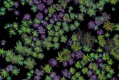 Read more about Accurate aerial identification of tree species
Accurate aerial identification of tree species
In a recent study, multi-channel laser scanning and deep-learning methods correctly identified tree species from a distance.
ResearchFinnish Geospatial Research Institute (FGI)Press release
More information
For media
Our Communication Services assist media representatives in finding needed information, photographs and experts.