We are developing automated methods for interpretation and change detection of remotely sensed data. The objective is to utilise the results, for example, in the mapping and updating of topographic objects and in the monitoring of land use. Object-based and knowledge-based interpretation methods are applied in the research.
Buildings
Buildings are important objects for map updating. They are also promising objects for automatic interpretation applications because they can be found relatively reliably from current laser scanner and aerial image datasets. Research carried out at the Finnish Geodetic Institute has included method development and testing in different areas and with different datasets. The results show that the majority of buildings can be detected automatically and that change detection provides useful information on new, demolished, and changed buildings.
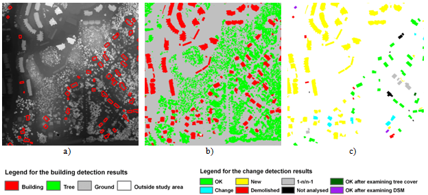
a) A digital surface model created from laser scanner data and old building vectors,
b) results of automatic building detection,
c) results of automatic change detection.
Buildings of the old map © The National Land Survey of Finland 2001.
Field parcels
We are carrying out research to develop automatic methods for change detection of agricultural field parcels (the Finnish Land Parcel Identification System). The objective is to to use new aerial ortho images and object-based interpretation to detect parcels that include non-field objects and thus need updating.

Automatically detected changes inside field parcels (outlined in red colour).
Map and aerial image data © the Agency for Rural Affairs and aerial images suppliers.
Land use / land cover
We have also studied automatic land use / land cover classification. SAR images, laser scanner and aerial image data, and optical satellite images have been used in the studies. The research has shown that promising results can be obtained by using object-based interpretation methods and good datasets. The results have been good, evaluated both visually and numerically on the basis of classification accuracy.

Results of automatic land cover classification. Multitemporal interferometric SAR data were used in the classification. Classes: forest, open area, built-up area (three classes according to building density), water mask, missing data. SAR data and water mask © M. Engdahl.

Results of automatic land cover classification. Laser scanner data and an aerial ortho image mosaic were used in the classification. Classes: building, tree, vegetated ground, non-vegetated ground.
Object-based and knowledge-based interpretation
Object-based and knowledge-based interpretation methods have been applied in our research. In object-based interpretation, homogeneous objects or regions are interpreted instead of single pixels. Objects or regions are obtained from image segmentation, map data, or combination of these. Knowledge-based interpretation can be based on user-defined rules, and it allows to combine information from different remotely sensed datasets and existing maps. Rules can also be developed automatically, for example, by applying the classification tree method.

Segmentation of a Landsat TM satellite image into homogeneous regions (Figure from the report: Matikainen, L., Yu, X., Kuittinen, R. and Ahokas, E., 1997. Updating topographic maps by using multisource data and knowledge-based interpretation. Reports of the Finnish Geodetic Institute 97:1.).

Snow cover percentages of drainage areas on 20 April 1999 estimated from a NOAA AVHRR satellite image. Drainage areas © Finnish Environment Institute. (Figure from the report: Matikainen, L., Grandell, J., Kuittinen, R. and Vepsäläinen, J., 1999. Snowmelt monitoring using multisource satellite image and ground measurement data. Reports of the Finnish Geodetic Institute, (99:8), 46 p.). Further information on the method: Matikainen, L., Kuittinen, R. and J. Vepsäläinen, 2002. Estimating drainage area-based snow-cover percentages from NOAA AVHRR images. International Journal of Remote Sensing, Vol. 23, No. 15, pp. 2971-2988. http://www.tandfonline.com/doi/abs/10.1080/01431160110071923