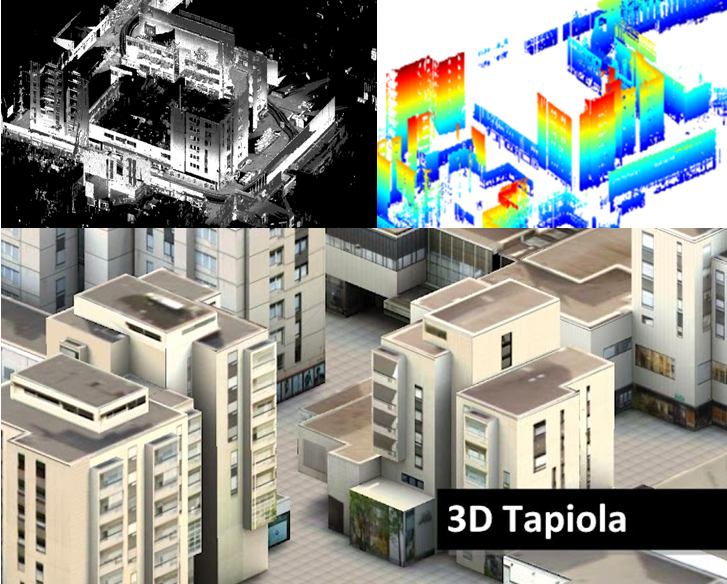
Figure 1. The process from a laser scanner point cloud into a 3D model. A dense laser scanner point cloud from the centre of Tapiola, acquired by mobile laser scanning, is shown top left. Building facades, extracted from the point cloud, are shown top right. A photorealistic 3D city model is obtained when details from photographs are added to the facades (shown in the lower half).
Accurate and up-to-date geographic information is needed by society for various activities and, increasingly, also in everyday life. Examples of this include city planning, forestry and car navigators. Maps, images and models of the built environment provide important background information for city planning and construction. In forestry, information is needed on the forest volume and tree species. Driving with the assistance of a car navigator would not be possible without accurate road maps.
Remote sensing and photogrammetry have a central role in the acquisition of geographic information. They provide techniques that are used to acquire, process and interpret images and other measurement data on the environment in order to extract useful information. Data are acquired from airplanes, satellites and terrestrial vehicles. The data are stored in a digital format on computers, and they are processed by using computational methods.
Work is carried out at the FGI, in the Department of Remote Sensing and Photogrammetry, to develop new and efficient methods for acquiring and processing data. In particular, the objective is to develop automated methods that could be used to acquire more diverse information on the environment more frequently than before. Acquisition of 3D (3-dimensional) information also has a central role in developing methods. Traditionally, maps have provided 2D information on the environment. On a topographic map, for example, a typical building is represented by a rectangle that shows the location and size (basal area) of the building. Modern data acquisition techniques, however, provide good possibilities for acquiring 3D information. A 3D model of a building shows the height of the building in addition to the basal area. A detailed model also presents the shape of the roof. The most detailed models can present accurate information on the colours and materials of buildings, and on the location of windows and doors. The models can also show individual trees and other useful objects, such as pylons. These types of models allow a very natural-looking representation of the environment on a computer. They are useful for various planning tasks, but they are also useful for illustrating the environment for use with applications, such as navigation. It is easier to perceive the environment from a natural-looking model than from a 2D map.
Data acquisition
Important data acquisition methods for mapping include aerial laser scanning and aerial imaging. A laser scanner sends laser pulses towards the ground and measures the reflection of the pulses back to the device. The pulses reflect from buildings, trees, the ground surface and other objects on the terrain. On the basis of the travelling time of the pulses, it is possible to calculate the distance between the laser scanner and objects on the terrain. This provides a dense point cloud representing the height of the terrain. In addition to using conventional aircraft for aerial imaging, laser scanner and image data are nowadays also acquired from terrestrial vehicles and unmanned aerial vehicles (UAVs). Using devices installed on top of cars, it is possible to acquire accurate information on objects along the streets. This information can be used for detailed 3D city models. In the mapping of large areas, satellite images can be used in addition to aerial images.
Data processing

Figure 2. Processing of the data is carried out by computer. A digital surface model (DSM) derived from laser scanner data is shown on the left. High objects are light and low objects are dark in the DSM. The results of automated classification are shown on the right (buildings are in red, vegetation in green and the ground surface in grey).
Laser scanner and image data are stored in digital format on a computer, which allows the processing of the data by using computational methods. The original laser scanner data consist of points with x, y, and z coordinates (i.e. a point cloud). Images are in raster format, i.e. they consist of pixels with grey level values. To simplify, it can be said that the format is similar to that of pictures taken with a digital camera and stored on a computer.
Before 3D models are obtained from the acquired data, many processing steps are needed. The first of these is preprocessing of the data. Images and laser scanner data must be transformed into an appropriate coordinate system and into a format that is suitable for further processing. For example, it is often desirable to convert pointwise laser scanner data into raster models. The grey level values of images may need correcting so that values in different areas are comparable to each other.
In order to automate the modelling of objects, an important processing step after preprocessing is the automatic recognition of different objects. Buildings and roads, for example, are detected automatically from image and laser scanner data. This is carried out, for example, by using segmentation methods that recognize homogeneous regions and classification methods that can be used to classify the regions into classes such as building, road, forest and field. The classification is often based on statistical methods that compare the properties of objects to known objects.
After the preliminary recognition of objects, the next step is the actual modelling stage. Geometric elements such as lines, planes and solids are used to represent objects. For example, corner points are found for buildings and these are used to form the outlines of the buildings. A roof can be modelled by fitting planes to laser points reflected from the roof. In detailed virtual models, texture is assigned to objects. For buildings, for example, this means that the facades of the buildings are represented in a natural way by using photographs. Automatic recognition and modelling of objects are demanding tasks. To achieve the best final results, manual work is still needed.
Applications
Applications related to the topic are presented on the following pages: