The FINNARP expedition has returned to Finland from Antarctica after a two-month expedition. The expedition, worked in the Finnish Aboa Research Station, updated the 24/7 measuring devices in the area and installed two new reflectors for remote sensing satellites utilising radar wavelengths.
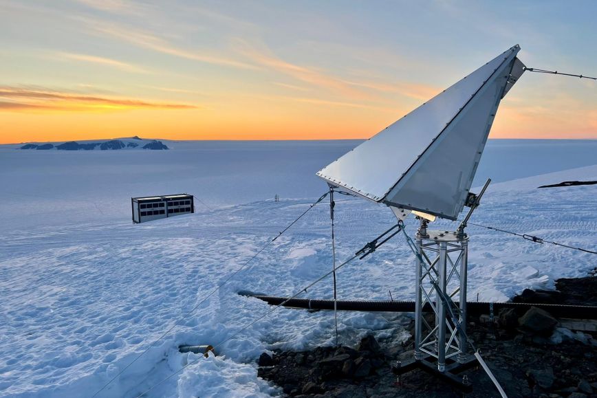
The reflectors are the largest in Antarctica and will enable a new method for measuring the tectonic shift in the area with satellites. They can also be used for other purposes such as more accurate glacier movement measurements carried out by glacier researchers.
‘The expedition was lucky in terms of weather; there were no strong storms in the Aboa area, and we managed to complete all the work as planned,’ says the expedition leader, Mika Kalakoski, from the Finnish Meteorological Institute.
To carry out demanding research work at the Antarctica, the research station must be professionally maintained, and maintenance must be carefully planned.
‘Cooperation between the expedition members is a necessity, but functional vehicles, water and food supply, medical services, and good communication connections also play key roles,’ says Kalakoski, backed up by his 25-year experience from Antarctica operations.
The expedition included seven specialists: the expedition director; a senior planning officer; a chief engineer; a doctor; a housekeeper; and two researchers.
Valuable additional data and long time series about tectonic shift
The researchers of the National Land Survey’s Finnish Geospatial Research Institute FGI performed geodetic measurements in Antarctica and updated the measuring infrastructure, which will now serve the area’s geodetic and geophysical research long into the future.
‘The goal of our research is to deepen our understanding of the tectonic shift in western Queen Maud Land. Ice covers 95 per cent of Antarctica, and direct measurements can only be carried out in areas with a stable rock base. Aboa is one of the few areas where this is possible,’ says research manager Jyri Näränen from the NLS.
The researchers of the predecessor of the Finnish Geospatial Research Institute – the Geodetic Institute – participated in the very first FINNARP expeditions in the early 1990s. Even at the time, they were using the era’s state-of-the-art GPS measuring devices and gravity meters.
‘Time series of the tectonic shift and changes in gravity that span 30 years or more are essential, as these movements are slow, and any changes become visible with a delay. This season, we used satellites to measure the height of the glacier in places where its height was first measured in 1990. Based on the initial results, the height of the glacier surrounding Aboa has grown by several metres in these 30 years. This is explained by increased rain due to the warming climate. This result is also supported by the fact that gravity has been increasing for the last 12 years due to the effect of the glacier’s growing direct gravitation. These results reinforce and support the observations made with satellites,’ Näränen explains.
The researchers also replaced the satellite positioning receiver, which had served the station for 20 years. The new device can receive signals from all satellite positioning systems, including the European Galileo system. The device will continue a 20-year time series of satellite positioning, covering a hole the size of thousands of square kilometres in the global satellite positioning network. In terms of its longitude, it is also located in a unique area.
The continuously measuring seismometer of the University of Helsinki’s Institute of Seismology was also replaced with a new one.
‘After these installations, Aboa now has a unique geodetic and geophysical measuring infrastructure in Queen Maud Land,’ says Jyri Näränen.
Regular expeditions from Finland to Antarctica
As a member state of the Antarctic Treaty, Finland has a permanent research station in Antarctica, and the Treaty requires the members to carry out significant research operations in the area. The Finnish research station, Aboa, is in Queen Maud Land, about 130 kilometres inland. Aboa was built during the 1988–1989 Antarctica summer.
About two months of work are done at the Aboa research station every year, between November and February, i.e. the Antarctica summer, when temperatures are between zero and minus 20 degrees Celsius. Continuous daylight, strong sun radiation and harsh snowstorms are typical of summer in Antarctica.
FINNARP (Finnish Antarctic research programme), operating as part of the Finnish Meteorological Institute, is responsible for the maintenance of Aboa, and organises the research programme’s fieldwork.
Additional information
FINNARP operations: Director Mika Kalakoski, Finnish Meteorological Institute, tel. +358 50 359 2792, mika.kalakoski@fmi.fi
Geodetic studies: Research Manager Jyri Näränen, National Land Survey of Finland / Finnish Geospatial Research Institute FGI, jyri.naranen@nls.fi, tel. +358 50 435 7258
Read more about FINNARP operations: www.antarctica.fi (in Finnish)