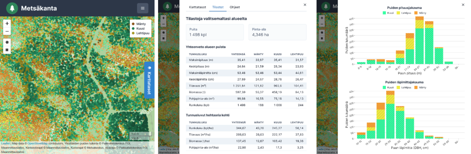
The UNITE competence centre has developed methods to produce data at the level of individual trees. The forest database’s map view enables users to view all individual trees sorted by length and tree species. The data are calculated based on the National Land Survey of Finland’s (NLS) laser scanning data. The map clearly visualises the regional distribution of trees and also offers data on felling potential.
The interpretation of individual trees enables more accurate data on forest resources
‘The forest database has been developed to make it easier to visualise forests and view statistical data. Its map view and comprehensive statistical data help identify the financial value of forests and the need for forest management. The forest database calculates statistical data over an area of up to thousands of hectares in only a few seconds,’ says Matti Hyyppä, assistant researcher at the Finnish Geospatial Research Institute (FGI) of the NLS, who is in charge of IT implementation.
The interpretation of individual trees also enables better felling plans. As a result, the trees that need to be removed can be felled, and the most vital trees can be left standing.
‘When trees are known in more detail, the most vital trees with the highest carbon sequestration capacity can be left standing in forests, and solutions that better support biodiversity can be made. In this way carbon sink capacity of forests can be increased by as much as ten per cent,’ says Juha Hyyppä, professor at FGI.
‘The current national laser scanning dataset may not yet be large enough for this optimisation, but more laser scanning data are being produced, providing more and more data on quality,’ Hyyppä says.
Aiming at high usability of data
To produce practical benefits from research data, the tools developed must be integrated into existing systems. Data provided by systems must be in such format that different users can use the data to make decisions.
‘A forest management planner may have more time and will to define what is included in calculations, while forest machine operators need data in as clear and simple a format as possible,’ says Heli Honkanen, senior specialist at FGI.
Achieving the various goals of forest management also presents a challenge to systems, and when preparing plans, systems must be able to produce data simultaneously for various decision-making processes that address different goals – it is impossible to optimise euros first and the carbon balance next.
The forest database system has been developed for a trial period, and its purpose is to demonstrate the possibilities of individual tree interpretation. The long-term goal is to integrate the currently developed methods of individual tree interpretation into forest data systems to serve data production processes. Quality data are added continuously. To interpret individual trees, reference data on each tree are required. We are continuously developing automated reference measurement systems that produce highly detailed quality data on trees. In their simplest format, quality data provide information on tree species and stem curves, while in their most complicated format, they offer additional information on tree density, knots and vitality.
‘An option to produce an automated virtual forest will also be added to the forest database system. It can be used to visualise forest management measures, for example. Our goal is to make the virtual forest so good that it helps identify real-life counterparts in actual forests,’ says Juho-Pekka Virtanen, project researcher at FGI and product owner at Forum Virium.
To test the forest database system, we are looking for people who work with forest data systems, and who want to give feedback on the system’s operation for further development. If you want to test the system, contact the system administrator (matti.hyyppa@maanmittauslaitos.fi).
Additional information
Juha Hyyppä, director, juha.hyyppa@maanmittauslaitos.fi
Matti Hyyppä, assistant researcher, matti.hyyppa@maanmittauslaitos.fi
Juho-Pekka Virtanen, project researcher, juho.virtanen@maanmittauslaitos.fi
Heli Honkanen, senior specialist, 040 661 6004, heli.honkanen@maanmittauslaitos.fi