The researchers of the Finnish Geospatial Research Institute of the National Land Survey of Finland, the Natural Resources Institute Finland and various universities have developed the surveying process based on laser scanning into such an efficient method that it helps the forest industry save tens of millions of euros every year through forest inventory based on laser scanning. The savings of the inventory introduced in 2008 are facilitated by the method’s cost efficiency.
The next stage of this progress is now near: The newest methods will enable producing accurate forest data up to the level of individual trees. When these methods will be introduced more extensively over the next few years, savings worth millions will be achieved in forest trade again, and support for biodiversity and carbon sequestration will improve further.
For a long time, the Finnish forest industry has had the vision of “sustainable wood supply, creating added value to the wood value chain, 30 per cent increase in cost efficiency”, and a method discerning individual trees, or the interpretation of individual trees, is part of this improved and more efficient value chain.
“Forests are vital to the economy and biodiversity and they are key carbon sinks. That’s why there is a growing demand for exact and up-to-date forest data,” says Professor Juha Hyyppä from the NLS’s Finnish Geospatial Research Institute FGI.
“Our research enables more efficient collection of highly accurate forest data. This will allow us to take the goals of forest management better into account. For example, if surveying hundred trees takes one day with two people, we can do the same in a minute with mobile laser scanning or a drone,” he says.
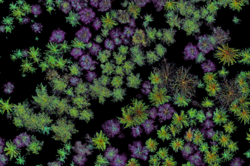
“Going forward, the Finnish Geospatial Research Institute will be able to calculate Finnish forest resources at the level of individual trees as the national laser scanning process progresses. Our demo can be found at metsakanta.com. The accuracy will improve further if the point density continues to grow,” says Juha Hyyppä.
“The goal is to have more than a billion trees in the demo in autumn, although right now the number is only slightly over 100 million.”
Greater accuracy, greater benefits
The Natural Resources Institute Finland has made calculations about the financial advantages of the method based on the interpretation of individual trees.
“The more reliable the data is, the greater monetary value it has. For example, if the measured accuracy of tree volumes increases by one percentage in the whole country, forest owners will gain €80 million more in earnings during a decade. This is a consequence of finding the good felling sites more likely and being able to time the felling better than before. Exact data makes for better decisions,” summarises Natural Resources Institute Finland’s research professor Annika Kangas, who is part of the UNITE project.
The goal of the Finnish Forest Centre, which carries out forest inventories in Finland, is to commission the method for interpreting individual trees developed by the researchers in the next few years. At the same time, companies will have the chance to develop their own commercial applications.
“The more purposes data has, the more valuable it is. The monetary value can be estimated separately for each different situation These may include situations such as the forest owner’s decisions regarding the felling schedule or the tree species to plant and the buyer’s decisions on stands marked for cutting, log cutting or forest machine routes. It has been estimated that the benefit for scheduling felling, for example, is €4 per hectare over ten years. The estimated value for selecting correct tree species to sites with heterobasidion is €35–98 per hectare over the entire cycle.
Kangas and Hyyppä are part of the UNITE flagship project funded by the Academy of Finland which studies and develops the collection of forest data through new technologies. The UNITE project is implemented by the University of Eastern Finland, the National land Survey of Finland’s Finnish Geospatial Research Institute, the University of Tampere, and Natural Resources Institute Finland (Luke).
Most vital tree species to bind carbon
Learn more about the inventory of forests on the level of individual trees at metsäkanta.com (in Finnish), which features species-specific size distribution and quality data. These are for industrial needs. The objective is to provide more information about the growth rate of individual trees, which reflects their carbon sequestration. The data on trees’ age and species, on the other hand, gives more information about biodiversity.
“The interpretation of individual trees gives forest owners the chance to plan their felling projects better and fell the required tree species. This will allow leaving the trees with the best vitality and carbon sequestration ability to grow in the forests,” states Juha Hyyppä.
However, the interpretation of individual trees does not remove the need for other inventory methods, as regional and national forest inventories focus on producing exact tree characteristics. Interpretation of individual trees shows where individual large trees are and describes the value of timber, in particular, better than the traditional inventory methods.
The development of forest carbon sinks still requires more accurate forest resource data, but the national laser scanning material used as its basis is constantly growing denser, thanks to which more and more quality information will become available in the future.
Taking the newest forest inventory methods into practice
In 2023–2025, the Finnish Forest Centre, together with Metsähallitus Metsätalous Oy and the National Land Survey of Finland, will review the introduction of new methods of forest resource data and the interpretation of individual trees in the third national laser scanning and aerial photography programme starting in 2026.
The practical goal is to combine the interpretation of individual trees, which suits older forests better, with the current, regional method that is still required for the inventory of young stands or forests. One key factor in tree interpretation is a high-quality test plot material that is representative of the area’s forests. The Finnish Forest Centre has introduced tree map test plots where all trees are carefully measured and located in the terrain. This material is also excellent for the interpretation of individual trees.
Together with other geospatial data, more accurate remote sensing better enables producing data related to the biodiversity of forests and nature management, which will also be developed further towards the next inventory round.
More information
Department Head, Professor Juha Hyyppä, Department of Remote Sensing and Photogrammetry, Finnish Geospatial Research Institute of the National Land Survey of Finland FGI
firstname.lastname@nls.fi
Research Professor Annika Kangas, Natural Resources Institute Finland
+358 295322461
firstname.lastname@luke.fi