An airship has been flying in the airspace above the Koli National Park this summer to provide research scientists with valuable information about changes in forest health. Koli was selected as the research area as European spruce bark beetles have caused massive damage there. Trees in the area are affected by snow, drought, fungal diseases and large bark beetle populations. When becoming abundant, bark beetles can even kill forests extensively.
Research scientists from the Finnish Geospatial Research Institute (FGI) of the National Land Survey of Finland (NLS) and the University of Eastern Finland (UEF) are developing methods to forecast and manage bark beetle damage. They obtain up-to-date information about the condition of trees using equipment such as drones equipped with accurate measuring devices to measure and record forests from a distance and produce accurate information for further analyses.
‘Our aim is to develop a method to effectively identify trees colonised by bark beetles from drone images and estimate any decreases in the condition of trees. Another goal is to develop damage risk and spread models for Finland’s conditions. To this end, we are weekly monitoring in field the symptoms caused by bark beetle populations in spruce trees and any changes in them,’ says Päivi Lyytikäinen-Saarenmaa from UEF.
Cost-effective information about forest damage using an unmanned airship
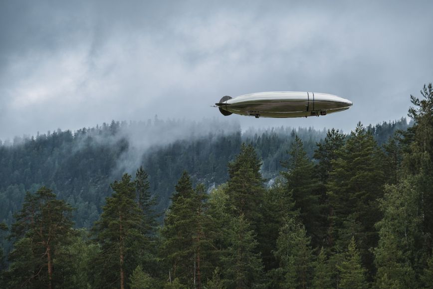
In Koli, researchers of forest damage are producing new scientific information and using the most recent technologies. This summer, the Joensuu-based company Kelluu has provided the research scientists with imaging services. Its new unmanned airship is equipped with accurate measuring devices, including a multispectral camera.
‘The airship allows us to identify any changes in tree crowns, including changes in the needle colour through yellow and reddish brown to grey, which is an indication of tree death. We are studying how soon we can identify changes after swarming and infestations. If trees housed and weakened by bark beetles can be identified early enough before the next generation matures, the trees can be removed from the forest to slow the spread of pests,’ says Eija Honkavaara, Research Professor at FGI.
Information about symptoms and images are fed into a program which uses machine learning to generate a model of spruce health.
Low emissions, agility and speed as advantages of drones
Research scientists have also used drones and AI before to collect forest data, but airships represent the latest technology and are being used for the first time in Koli.
The Kelluu airships used in the project are fuelled by hydrogen. This means that daily operations of 12 hours generate no carbon dioxide emissions. In Koli, the airship has been operated from Joensuu without any visual contact.
‘The airship is operated by an autopilot, while accurate camera systems record the environment in great detail,’ says Jiri Jormakka, COO at Kelluu.
Kelluu’s high-resolution imaging system equipped with multispectral technology detects bark beetle damage already when no discernible changes can be seen with the naked eye.
‘Unmanned airships add agility and speed to monitoring. They can be flown under the clouds, generate lower emissions and are more affordable than airplanes or helicopters. Autonomous drones combined with AI, in particular, can be used broadly in science and society alike. Managing bark beetle damage is an excellent example,’ says Honkavaara.
More information
Eija Honkavaara, Research Professor, FGI, +358 29 531 4716, firstname.lastname@nls.fi
Päivi Lyytikäinen-Saarenmaa, Senior Scientist, University of Eastern Finland, Department of Forest Sciences, +358 40 8254465, paivi.lyytikainen-saarenmaa@uef.fi
The study is part of the RESDINET project funded by Horizon Europe. The project enhances networking activities between research institutions in widening countries (Institute of Forest Ecology, Slovak Academy of Sciences, IFE SAS) and top-class counterparts at the EU level (Finnish Geospatial Research Institute, the University of Eastern Finland, and the Swedish University of Agricultural Sciences). An initial network will be established and a new shared research project will be developed in the project, focusing on the application of new remote sensing technologies (RST) in the forest disturbance ecology. The project builds on networking for excellence through the transfer of knowledge and the exchange of best practices between the involved institutions.
Research groups are part of the Academy of Finland flagship UNITE that researches and develops the Forest-Human-Machine Interplay by for world’s leading research groups in forest sciences, spatial data and sensor development, as well as gamification. The UNITE is a flagship consortium of School of Forest Sciences of University of Eastern Finland, Natural Resources Institute Finland, Finnish Geospatial Research Institute of National Land Survey of Finland and University of Tampere that cooperates with a large network of partners.