Search in newsroom
-
 Read more about How does land surveying work?
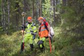
How does land surveying work?
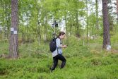
Land surveying began in Finland in the 17th century. The need for surveying has not disappeared over the centuries – we still need to know where roads, fields, forests, plots and properties are located. Surveying tools have evolved and the work has become more automated.
Cadastral surveySurveyingMaps -
 Read more about Location Innovation Hub to be established in Finland
Location Innovation Hub to be established in Finland
The goal is to support companies and society at large in using geospatial data, especially in the areas of the built environment, bioeconomy, transport and welfare.
Spatial dataFinnish Geospatial Research Institute (FGI)Innovations -
 Read more about Drones to compete in challenging delivery tasks
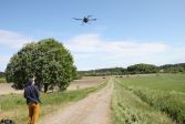
Drones to compete in challenging delivery tasks
Can a drone deliver a package from land onto a boat? Can a drone be operated out of sight? These kind of challenges competitors will face at the Drone Tournament.
ResearchFinnish Geospatial Research Institute (FGI) -
 Read more about Cottage owner’s checklist
Cottage owner’s checklist
When summer and the cottage season begin, many people are concerned about things related to the cottage and its ownership. The National Land Survey compiled a concise information package for cottage owners.
Real propertyCustomer ServicePress release -
 Read more about This is how you can identify NLS cartographers
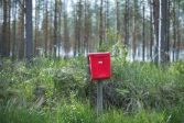
This is how you can identify NLS cartographers
The National Land Survey of Finland’s (NLS) cartographers spread out once again across Finland to specify geospatial data. You can identify NLS cartographers from their work clothing and the organisation’s logo on their vehicle.
Press releaseSpatial dataMaps -
 Read more about Dust trail of the largest known comet outburst to be captured
Dust trail of the largest known comet outburst to be captured
The hourglass pattern formed by the particles in the trail of the comet was directly observed for the first time in this study.
ResearchFinnish Geospatial Research Institute (FGI) -
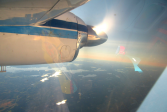 Read more about Seen an airplane circling in the sky? The aerial photography and laser scanning season has started
Seen an airplane circling in the sky? The aerial photography and laser scanning season has started
In the spring, you might spot a plane circling in the sky for a longer time. The plane is probably taking aerial photographs.
Press releaseLaser scanningAerial photography -
 Read more about The most common causes of GNSS interference
The most common causes of GNSS interference
The authorities monitor the quality of signals and respond to any irregularities.
Satellite positioningFinnish Geospatial Research Institute (FGI)Research -
 Read more about Sustainability is everyone’s responsibility
Sustainability is everyone’s responsibility
The National Land Survey Finland has published its 2021 sustainability report. The report details the sustainability measures implemented during the year and outlines our long-term sustainability development plans. In the future, the NLS’s sustainability development will be steered by the ‘Responsibility for the Earth’ sustainability programme.
Sustainability -
 Read more about Vertti robot to the rescue – this is how RPA was introduced to the NLS
Vertti robot to the rescue – this is how RPA was introduced to the NLS
You may have heard about RPA or process automation robots, but do you know what they mean? Robotic process automation (RPA) has become an everyday practice in the operation and customer service of the National Land Survey of Finland (NLS).
NLS
Searching for Service messages?
Service messages are published under Our online services. There you can also check the availability of applications and services.