
No significant changes on the Norway–Finland border
The Finnish and Norwegian border commissions have reviewed the 737‑kilometre state boundary. In connection with the review, the boundary was measured, and all 209 border markers were checked, maintained, and documented.
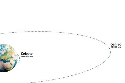
Can Low-Earth-Orbit satellites improve positioning resilience against GNSS jamming?
Researchers from the Finnish Geospatial Research Institute (FGI) are contributing to the Celeste project by evaluating the performance of the Celeste IOD signals in the Arctic region.

Use of property data increased by 16% in 2025
The use of property data produced by the National Land Survey of Finland (NLS) increased by more than 16% in 2025 compared to the previous year. Among other factors, the growth is underpinned by EU regulation, which directs banks to maintain increasingly detailed information about collateral items.

Satellite positioning interference at different flight altitudes examined with a prototype device
Researchers installed a satellite positioning interference testing device on an electric aircraft in Lappeenranta.
Major obstacle eliminated from the use of spatial data
The Location Finland service, developed by the Finnish Geospatial Institute, was included in the Data Economy Spotlight 2026 list.