Analysis and visualisation of geospatial data (GeoVA)
The Analysis and Visualisation of Geospatial Data (geoVA) research group is comprised of experts in geography, geoinformatics, surveying, cartography, and computer science. Their research topics are from the fields of map design, geovisualisation, terrain analysis, and geocomputation. The aims are to find new methods for analysing and visualising uncertain spatial and temporal data, as well as adapting methods of parallel computing to resolve the challenges introduced by the use of massive data sets and complex analysis tasks. In addition, the group supports other teams of the institute on issues related to map design, cartography, and data analysis
Their research topics are from the fields of map design, geovisualisation, terrain analysis, and geocomputation. The aims are to find new methods for analysing and visualising uncertain spatial and temporal data, as well as adapting methods of parallel computing to resolve the challenges introduced by the use of massive data sets and complex analysis tasks. In addition, the group supports other teams of the institute on issues related to map design, cartography, and data analysis
Contact persons
Departments
News
27-Mar-2017 New paper "A design of contour generation for topographic maps with adaptive DEM smoothing" by Pyry, Christian and Juha published in International Journal of Cartography. Open access here.
14-Jun-2016 Juha, Pyry, Cecilia and Christian organising and presenting in AGILE 2016, Helsinki.
10-Mar-2016 New paper "Conflation of OpenStreetMap and Mobile Sports Tracking Data for Automatic Bicycle Routing" by Cecilia and Juha out now in Transactions of GIS. Full paper is available here.
31-Jan-2016 Call for contributions is open for the AGILE 2016 workshop "Code Loves Maps" by Pyry et al.
14-Dec-2015 Christian's Master's thesis (Tech.) is ready! "Automated map generation process for tiled raster maps"
3-Dec-2015 Juha and Christian in EuroSDR meeting Amsterdam "EuroSDR/ICA NMA-generalisation workshop", presentation "Needs for automatic generalisation in the forthcoming National Topographic Database of Finland".
3-Nov-2015 Juha (with Antti Jakobsson and Paula Ahonen-Rainio) at GI Expo: We Love Maps! Maps for tomorrow - Signs of change
12-Oct-2015 ICA´s Map of the Month 10/2015: "Project Supra – Real-time heatmaps from sports workouts"
29-Sep-2015 Juha Oksanen in Karttakeskus GI Seminar 2015: "Added value from Big Data? Odds and oddities in utilising crowdsensed data from mobile sports application"
24-Sep-2015 Supra journal article out: "Generating Heat Maps of Popular Routes Online from Massive Mobile Sports Tracking Application Data in Milliseconds While Respecting Privacy" by Sainio, Westerholm and Oksanen. [HTML]
23-Sep-2015 Janne Kovanen and Juha Oksanen in the MMEA final seminar, Vaisala Ltd, Vantaa.
22-Sep-2015 Supra live demo now open!
5-Sep-2015 Supra journal article out: "Methods for deriving and calibrating privacy-preserving heat maps from mobile sports tracking application data" by Oksanen, Bergman, Sainio and Westerholm.
28-Aug-2015 Supra demo wins ICA Map Award!
20-Aug-2015 Pyry Kettunen and Juha Oksanen in the ICC 2015 conference. Pyry's oral representation "Elements of Geospatial Images to Support Cognitive Tasks in Wayfinding".
20-Aug-2015 Pyry Kettunen in the Advances in Cartographic Practice in the Classroom and on the Web pre-ICC workshop of the Commissions on Maps and the Internet, and Education and Training. Oral presentation "Interactive Web Map for Visual Analytics of Field and Point Motion using Layered Animation".
14-July-2015 Juha Oksanen in Evolving GIScience workshop, Leicester. Oral presentation "Uncertainty-aware Catchment Delineation Finally Possible for Interactive Analysis and Country-wide DEMs".
17-June-2015 Janne Kovanen in 10th Baltic Sea Science Congress. Oral presentation "An Open-Source based System for Near-Real Time Sea Flood Extent Web Maps for the Southern Coast of Finland". Abstract book
11-Jun-2015 Cecilia Bergman in AGILE Conference "Optimization of Circular Cycling Routes based on Mobile Sports Tracking Application Data" (poster).
09-Jun-2015 Cecilia Bergman in RICH-VGI: enRICHment of volunteered geographic information (VGI) workshop (http://k1z.blog.uni-heidelberg.de/2015/06/10/rich-vgi-workshop-at-18th-a... lisbon/) in AGILE Conference: "Representativeness of crowdsourced cycle volumes: Exploring the challenges and possibilities of mobile sports tracking application data".
09-June-2015 Pyry Kettunen in the AGILE 2015 conference. Oral representation "Empirical construction of a landmark ontology for wayfinding in varying conditions of nature".
21-May-2015 Pyry Kettunen in the APCPP 2015 conference. Invited oral presentation "Spatial cognition research to support wayfinding - studies on geospatial images and landmarks in nature".
20-May-2015 Juha Oksanen in the Geoinformatics Research Days. Key-note lecture "Liikuntasovelluksella kerätyn big datan käytön mahdollisuudet ja haasteet (Odds and oddities of utilising big data from mobile sports tracking applications)".
23-Mar-2015 Pyry Kettunen in the Spring Seminar of the Cartographic Society of Finland. Oral representation "Luonnon maamerkkien ja geospatiaalisten kuvien rakenneosien analyysi reitinkulun tukemiseksi".
25-Nov-2014 Juha Oksanen in the NovTecEx seminar: Spatial data analysis and modeling, Geological Survey of Finland. Oral presentation "Uncertainty-aware terrain analysis utilizing high-performance computing".
14-Nov-2014 Juha Oksanen and Janne Kovanen in the LuHaGeoIT final seminar.
4-Nov-2014 ProGIS Thesis Award to Pyry Kettunen at GIS Expo 2014. Oral representation "Luonnon maamerkkien ja geospatiaalisten kuvien rakenneosien analyysi reitinkulun tukemiseksi".
4-Oct-2014 Pyry Kettunen defended his doctoral dissertation "Analysing landmarks in nature and elements of geospatial images to support wayfinding" (online) in Aalto University School of Engineering.
11-Sep-2014 Article "A User Study of Experimental Maps for Outdoor Activities" published in Cartographica.
6-Sep-2014 Article "A full graphics processing unit implementation of uncertainty-aware drainage basin delineation" published in Computers & Geosciences. Source codes are available at GitHub.
1-Jul-2014 Cecilia Bergman and Juha Oksanen in Mobile Tartu 2014 -conference. Oral presentations "Conflation of OpenStreetMap and public Sports Tracker data for automatic routing" and "Where to ride a bike? Methods for deriving privacy-aware heat maps from mobile sports tracking application data".
18-Jun-2014 Xabier Eraña in INSPIRE 2014 -conference: "The utilization potential of airborne laser scanning in an INSPIRE-compliant hydrographic data revision".
3-Jun-2014 Ulla Pyysalo in AGILE-conference: "Visualization of uncertain catchment boundaries and its influence on decision making".
16-Apr-2014 Xabier Eraña in GISRUK 2014 -conference: "Updating of hydrographic features in topographic base information based on airborne laser scanning data".
7-Nov-2013 Juha Oksanen in GIS Expo 2013: "Missä ovat parhaat liikuntareitit? Teholaskennalla lisäarvoa sijaintipohjaisiin palveluihin".
4-Nov-2013 Juha Oksanen in Smart environment information seminar: "Where to do sports? Visual data mining for finding routes from smartphone sports app data".
2-Oct-2013 Susanne Suvanto and Juha Oksanen in COST-arction MOVE Final Event: "Privacy aware density maps: Visualizing popular sports routes in the Helsinki region".
7-Jun-2013 Ulla Pyysalo's ja Juha Oksanen's paper "Outlier highlighting for spatio-temporal data visualization" is published in Cartography and Geographical Information Science
24-May-2013 Article about the multitouch maps in the Finnish Nature Center Haltia in ESRI magazine (in Finnish)
23-May-2013 Juha Oksanen gave a presentation in the Geoinformatiikan tutkimuspäivät (Geoinformatics research days) ”Paikkatietojen käytön tulevaisuus - Näkökulmina teholaskenta ja vuorovaikutteisuus" (”The future in the usage of geospatial data – perspectives from high performance computing and interactivity”). (in Finnish)
30-April-2013 Web pages for project SUPRA are now open.
3-4-April-2013 Juha Oksanen in GISRUK conference in Liverpool, “Can binning be the key to understanding the uncertainty of DEMs?”.
28-March-2013 Paper ”From LiDAR Data to Forest Representation on Multi-Scale Maps” (Schwarzbach, Oksanen, L.T. Sarjakoski ja T. Sarjakoski) is published in The Cartographic Journal:
4-5-March-2013 Juha Oksanen ja Susanne Suvanto took part in meeting and workshop of COST MOVE network in Hamburg. Plans for project SUPRA were presented in the workshop, “Project SUPRA: Looking for routes from massive workout data”
11-March-2013 The Cartographic Society of Finland has chosen Susanne Suvanto’s and Juha Oksanen’s map ”Sipoonkorpi Nature Reserve, Unique Nature and Cultural Heritage inside the Helsinki Metropolitan Area” to be sent to the 2013 map exhibition of the International Cartographic Association (ICA) in Dresden.
1-Dec-2012 David Eränen's (Åbo Akademi) Master’s Thesis ”Uncertainty-aware drainage basin delineation from digital elevation models using graphical processing units” is completed, with Juha Oksanen as a supervisor.
23-27-Jun-2012 Juha Oksanen’s presentation ”Updating of the Finnish Drainage Basin System and Register – Case VALUE” in INSPIRE conference in Istanbul.
11-13-April-2012 Poster ”Simple Maps, A Concept of Plain Cartography within Mobile Context for Elderly Users” (Kovanen, Oksanen, L.T. Sarjakoski ja T. Sarjakoski) in GISRUK conference in Lancaster.
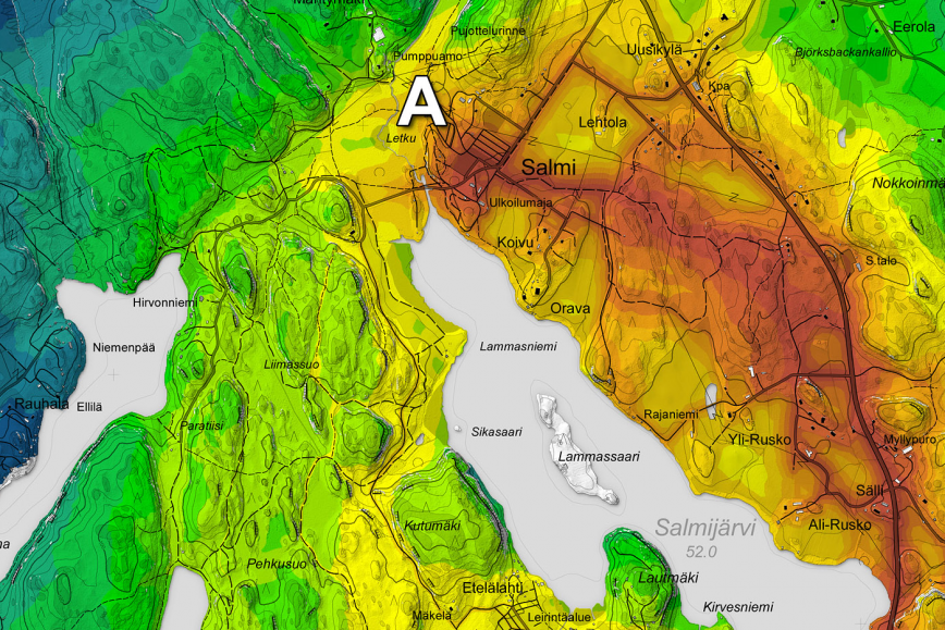
1-Feb-2012: ICA's Map of the Month from the FGI ICA's Map of the Month 2/2012 is "Hiking routes between Salmi and Oittaa". At the 25th International Cartography Conference in Paris, France, the map "Hiking routes between Salmi and Oittaa (Nuuksio National Park, Finland)" won the second jury's prize in the category Maps for Tourism. The jury stated: "Innovative experimental way of generating usable information about potential hiking routes between two popular entrances."