Metsähovi Geodetic Research Station has been part of the global DORIS Network since the 90's.The station was upgraded to meet the latest specifications in 2012. Doppler Orbitography and Radiopositioning Integrated by Satellite or, in French, Détermination d'Orbite et Radiopositionnement Intégré par Satellite (in both case yielding the acronym DORIS) is a French satellite system, operated by the French space agency CNES, used for the determination of satellite orbits (e.g. TOPEX/Poseidon) and for positioning.
Ground-based radio beacons emit a signal which is picked up by receiving satellites. This is in reverse configuration to other GNSS, in which the transmitters are space-borne and receivers are in majority near the surface of the Earth. A frequency shift of the signal occurs that is caused by the movement of the satellite (Doppler effect). From this observation satellite orbits, ground positions, as well as other parameters can be derived.
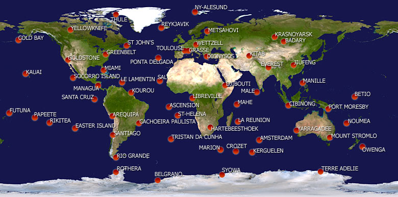
The ground segment includes about 50-60 ground stations, equally distributed over the earth and ensure a good coverage for orbit determination. DORIS beacons transmit to the satellites on two UHF frequencies, 401.25 MHz and 2036.25 MHz. The current missions with on-board DORIS receivers include, e.g., CryoSat-2, HY-2A, Jason-2, SARAL, and SPOT-4 and -5.
Apart from orbit determination, the DORIS observations are used for positioning of ground stations. The accuracy is a bit lower than with GPS, but it still contributes to the International Terrestrial Reference Frame (ITRF).
In 2012 a REGINA (Reseau GNSS pour l'IGS et la Nativation) receiver was added in Metsähovi. REGINA is a project by IGN and CNES in which most of DORIS stations are supplied also with GNSS receivers creating a global Network of receivers that are standardized and under control of a single organization.