The National Land Survey of Finland (NLS) has released a new geoid model to represent the shape of Earth, which is 30 per cent more accurate than the previous model. Until now, Finland’s official geoid model was FIN2005N00 with an accuracy of 2 cm. The accuracy of the new FIN2023N2000 geoid model is 1.4 cm.
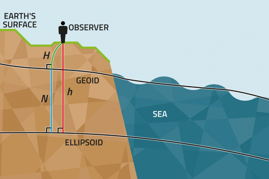
The geoid model determines the elevation based on the physical shape of Earth, which is required in satellite positioning but is not physically tied to Earth’s surface – and does not therefore indicate the direction in which water flows. The more accurate elevation data that can be obtained from the geoid model is, the more accurately the elevation can be determined in satellite positioning.
‘The requirements for the accuracy of geospatial data are constantly increasing. The new geoid model better responds to modern requirements for the accuracy of geospatial data,’ says Mirjam Bilker-Koivula, Group Research Manager at the Finnish Geospatial Research Institute (FGI) of the NLS.
The NLS has participanted in BSCD2000, the Baltic Sea geoid model developed in international cooperation, which responds to the needs of shipping and nautical chart makers. FIN2023N2000, Finland’s new geoid model, has been adapted to sea areas so that it is compatible with the new Baltic Sea geoid model.
The need for accurate geospatial data is increased by construction sites, port traffic, self-driving vehicles and the growing role of AI.
The accuracy of geoid models is maintained through continuous research
The NLS’s geoid model is based on years of hard work in geodesy research – the science that explores the size and shape of Earth and the location of its features.
‘In the north, tectonic uplift changes and distorts elevations, coordinates and gravity values. The geoid model needs to be updated to provide society with the most accurate and up-to-date elevation data,’ says Senior Research Scientist Timo Saari.
The previous geoid model was used for more than ten years. During that time, researchers had access to new datasets and methods that have been used in the new model.
‘In my doctoral dissertation, I studied the impact of gravity satellites and marine gravimetry on geoid modelling. The new model includes the datasets of the GOCE and GRACE satellite missions and the Gulf of Finland marine gravimetry campaign, which improve Finland’s geoid model both nationally and locally,’ Saari says.
The soon-to-end GeoVaPaa project funded by the Ministry of Forestry and Agriculture investigates what impact the resolution and accuracy of the gravity dataset have on the accuracy of the geoid model in Finland and whether the current gravity dataset meets the accuracy and resolution requirements set for the geoid model of the future.
‘The new geoid model offers the highest possible level of accuracy that can be achieved using current datasets. The geoid model was updated using gravity satellites, the elevation model based on national laser scanning, the harmonisation of gravity data, gravity measurements at sea, and the new GPS levelling dataset,’ says Bilker-Koivula.
The NLS uses the geoid model in various applications and services. The new model will be deployed in stages at the NLS.
Datasets
• FIN2023N2000 and its documents are available for download
• Baltic Sea conversion surface BSCD2000 and related data
• Timo Saari’s doctoral dissertation (2022) on the study of geoid models in Finland
Further information
Mirjam Bilker-Koivula, Group Research Manager, firstname.lastname@nls.fi, +358 29 531 4696, +358 50 5641 400
Timo Saari, Senior Research Scientist, firstname.lastname@nls.fi, +358 50 324 0214, +358 50 357 4315