News and articles
-
 Read more about Measurements ensure that no privately owned trees are felled
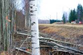
Measurements ensure that no privately owned trees are felled
This summer, the Centre for Economic Development, Transport and the Environment (ELY) of North Savo will cut roadside trees over some 250 kilometres to improve traffic safety. Some roads will be repaved while others will undergo structural improvements. The National Land Survey of Finland (NLS) will mark the boundaries of road areas.
Press releaseCadastral surveyReal property -
 Read more about Which interface should I choose – contractual or open access?
Which interface should I choose – contractual or open access?
The National Land Survey of Finland’s (NLS) open datasets are provided through contractual services subject to a separate charge and through open access interfaces free of charge. Is there any difference, and which service should I choose?
InterfacesSpatial dataReal property -
 Read more about Booking appointments to be tested at some National Land Survey service points
Booking appointments to be tested at some National Land Survey service points
At six National Land Survey service points, customer service by appointment will be tested in summer 2024.
NLSCustomer Service -
 Read more about The ESA EarthCARE satellite finally to launch – revolutionary for climate research
The ESA EarthCARE satellite finally to launch – revolutionary for climate research
Jarkko Koskinen, Deputy Director-General of the Finnish Geospatial Research Institute will be watching the launch of the satellite in California as the Chairperson of the Programme Board for Earth Observation of the ESA.
ResearchSpacePress release -
 Read more about Five questions that help you understand satellite positioning better
Five questions that help you understand satellite positioning better
Both natural and human factors cause interference in satellite positioning. However, the most critical systems do not rely on satellite positioning alone.
ResearchSatellite positioningPress release -
 Read more about GeoE3 strengthens the better availability of location data in Europe
GeoE3 strengthens the better availability of location data in Europe
Ended in February, the GeoE3 project offered a significant input for digitalisation in Europe.
Finnish Geospatial Research Institute (FGI)Spatial data -
 Read more about Four options presented in the National Land Survey's service point report
Four options presented in the National Land Survey's service point report
The service point survey reviewed options for the future service point network of the National Land Survey.
NLS -
 Read more about Global warming affects even the length of day
Global warming affects even the length of day
The Earth's rotation has concrete effects in our daily life. Any changes in Earth’s rotation directly affect the current global timekeeping and can cause problems for technologies that require precise time, such as navigation systems.
ResearchSatellite positioningMetsähovi -
 Read more about Data balance sheet: Residential and Commercial Property Information System highlighted in the 2023 figures
Data balance sheet: Residential and Commercial Property Information System highlighted in the 2023 figures
The National Land Survey of Finland’s (NLS) Data Balance Sheet 2023 has been published.
NLSSustainability -
 Read more about New shareholder – remember a power of attorney for the shareholders’ meeting
New shareholder – remember a power of attorney for the shareholders’ meeting
The season of shareholders’ meetings is currently underway. New shareholders can participate in the shareholders’ meeting of their housing company with a power of attorney provided by the seller, even if they had not yet been registered as an apartment owner in the Residential and Commercial Property Information System.
ApartmentsPress releaseResidential and Commercial Property Information System
More information
For media
Our Communication Services assist media representatives in finding needed information, photographs and experts.