News and articles
-
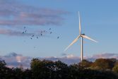 Read more about Land use agreements for wind farms are easy to improve
Land use agreements for wind farms are easy to improve
Wind power companies and landowners should agree on the use of roads more effectively than at present. When registering lease agreements, the National Land Survey of Finland (NLS) has noticed that information about a road is only given in the lease, and the road is not established through a private road survey.
Press releaseExpropriation surveyReal property -
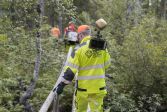 Read more about What is attractive about land surveying? Metropolia students say
What is attractive about land surveying? Metropolia students say
While land surveying may be a slightly less familiar field of study for many, it actually attracts a good number of applicants each year.
Surveying -
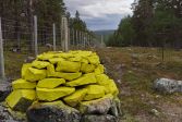 Read more about Enjoy the scenery and keep the area tidy
Enjoy the scenery and keep the area tidy
The border between Finland and Norway includes the maintenance of an open area on the border, the border corridor.
Press releaseNLSMaps -
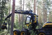 Read more about A smart harvester guides forest machine operators towards sustainable forest management
A smart harvester guides forest machine operators towards sustainable forest management
The IlmoStar research project is developing precise forest management based on accurate positioning data to help address biodiversity and carbon sinks even better than before.
Laser scanningResearchSatellite positioning -
 Read more about First in Europe: geospatial datasets now cross borders seamlessly
First in Europe: geospatial datasets now cross borders seamlessly
The Location Europe platform combines various data sources and supports the development of location-based services.
Spatial dataFinnish Geospatial Research Institute (FGI) -
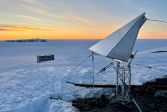 Read more about Glacier now several metres taller due to increased rain in Antarctica
Glacier now several metres taller due to increased rain in Antarctica
A Finnish expedition installed devices in Antarctica that enable more accurate research on the movement of Earth's crust and glaciers. The Finnish research station in Aboa is now a top-tier infrastructure measuring hub that will facilitate research in the area long into future.
ResearchPress releaseSatellite positioning -
 Read more about Crash of the ERS-2 satellite also carefully monitored in Finland
Crash of the ERS-2 satellite also carefully monitored in Finland
It has been estimated that the European Space Agency’s (ESA) ERS-2 satellite, used for remote sensing, will crash into the Earth’s atmosphere on Wednesday 21 February. The National Land Survey of Finland’s Finnish Geospatial Research Institute and the Finnish Meteorological Institute are closely involved in predicting and monitoring the movements of the resulting space debris.
SpaceResearchSatellite positioning -
 Read more about Customers satisfied with the NLS’s map image services
Customers satisfied with the NLS’s map image services
NLS’s customers are very satisfied with the map image services. Customers trust their availability, and the products received through the services respond to most users’ needs.
MapsInterfacesServices -
 Read more about Geospatial data as part of larger information assets in Europe
Geospatial data as part of larger information assets in Europe
The INSPIRE Directive plays an increasingly important role in solving environmental and climate change-related challenges.
Spatial data -
 Read more about Solutions for forest management through new research
Solutions for forest management through new research
Identifying trees in high detail using drones and maps will improve forest management in the future. The new research projects of the Finnish Geospatial Research Institute (FGI) of the National Land Survey of Finland (NLS) and the UNITE competence centre develop innovative solutions for the collection of forest data and accurate harvesting.
ResearchFinnish Geospatial Research Institute (FGI)
More information
For media
Our Communication Services assist media representatives in finding needed information, photographs and experts.