Usually, spring floods happen in Finland when the winter snow melts quickly or when spring rains begin to fall while the ground is still frozen. Flooding usually takes place especially in Lapland, Northern Ostrobothnia and Kainuu.
This year, forecasts show less flooding than average, which has its own impact: the lack of snow cover, the absence of flooding and the resulting hydrological changes can cause issues in areas where the hydrology depends on snow and meltwater. Accurate forecasts are needed because the changing climate has an effect on the flood risk, especially in Finland and the rest of the Arctic.
Flood risk management requires proactive knowledge of the impact that severe weather conditions have on rivers. In the Digital Waters flagship, which is funded by the Academy of Finland, researchers from the Finnish Geospatial Research Institute work together with universities and research institutes to collect accurate and varied data on water bodies. Measurements are made both in inland waters and on the Baltic coast at different times of the year, in winter under ice cover as well.
Based on the collected information, it is possible to create a digital twin of a river, for example. The twin can then be used to model the flood impact on the environment.
“Accurate measurements are important to research, but they also support authorities and local decision-makers, among others, where it is necessary to consider flood risks and their impact on land use planning,” says Research Professor Harri Kaartinen at the Finnish Geospatial Research Institute FGI.
“An accurate three-dimensional model of the riverbed helps to understand how floods and changing weather conditions shape aquatic environments and what kinds of risks this poses to both nature and the built environment,” he says.
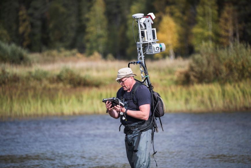
Drone boats boat environmental scanning backpacks collect accurate information on the environment
Reliable flood risk forecasts require accurately measured river data. Researchers of the Digital Waters flagship develop and use both mobile and fixed autonomous measuring devices that can collect accurate and up-to-date data from water bodies, even in hard-to-reach northern areas.
Some of their tools are a drone boat that maps riverbeds and a backpack-mounted laser scanner that collects environmental data.
They have been used to take measurements in the Oulankajoki, Tenojoki and Pulmankijoki rivers in northern Finland and in the Vantaa River in southern Finland. The measurements have been conducted by the Finnish Geospatial Research Institute (FGI) of the National Land Survey of Finland (NLS), the University of Turku, Aalto University, the Finnish Environment Institute, the Finnish Meteorological Institute and the University of Oulu. The study is a part of the Digital Waters (DIWA) flagship , and the equipment of the Hydro-RI-Platform research infrastructure, previously funded by the Academy of Finland and the European Union's NextGenerationEU programme, plays a key role in the collection of research data.
Additional information
Harri Kaartinen, Research Professor, Finnish Geospatial Research Institute (FGI) of the National Land Survey of Finland, +358 29 531 4756, firstname.lastname@nls.fi 