The publication of map and geospatial data products of the National Land Survey of Finland (NLS) depends on each product’s source. The terms of use and agreement terms and conditions of services indicate the uses for which each service is intended (e.g. downloading files or viewing finished products).
Open data products available from file download services
You can publish data openly and free of charge if you comply with the terms and conditions of the Attribution CC 4.0 licence for the NLS’s open datasets.
Laser scanning data
Laser scanning data are available as open datasets, while more accurate laser scanning data (5 p) are subject to a licence.
- Laser scanning data 0.5 p and laser scanning data 0.5 p (2008–2019) are open datasets. They can be used in accordance with the terms and conditions of the Attribution CC 4.0 licence for the NLS’s open datasets.
- Laser scanning data 5 p can be used freely within the organisation. The data cannot be published or transferred as such or at a similar accuracy. Read the terms of use for the data (in Finnish).
- Further information on the acquisition and terms of use of laser scanning data (in Finnish).
Printed maps and printouts, printout files
The NLS holds copyrights and intellectual property rights to printed maps and printouts produced in the topographic database and the title and mortgage register.
You can freely publish the NLS’s maps, provided that you comply with the following requirements:
- The publication must include the same © markings and warnings that are indicated in printed maps or map printouts:
- Topographic data © National Land Survey of Finland
- Property data © National Land Survey of Finland and municipalities
- Nautical chart data © Finnish Transport and Communications Agency Traficom
- Depth data © Finnish Environment Institute
- If the map to be published includes Traficom’s data (waterway/depth data), the following text must also be included: ‘WARNING: Not for navigation’.
- With regard to older maps (more than 50 years), information on the organisation that created the map must be indicated. For example, ‘© National Land Survey of Finland’ must be indicated in maps of the Land Survey Administration.
Example 1. An extract from the NLS’s map printout, in which the topographic map (topographic data), waterway data (nautical chart data) and lake depth contour lines (depth data) are indicated in a light colour. Property boundaries and identifiers (property data) are highlighted in red.
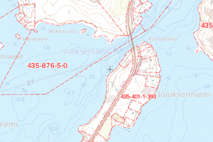
Topographic data © National Land Survey of Finland
Property data © National Land Survey of Finland and municipalities
Nautical chart data © Finnish Transport and Communications Agency Traficom
Depth data © Finnish Environment Institute
WARNING: Not for navigation.
Example 2. An extract from the NLS’s map printout with a topographic map (topographic data), waterway data (nautical chart data) and lake depth contour lines (depth data).
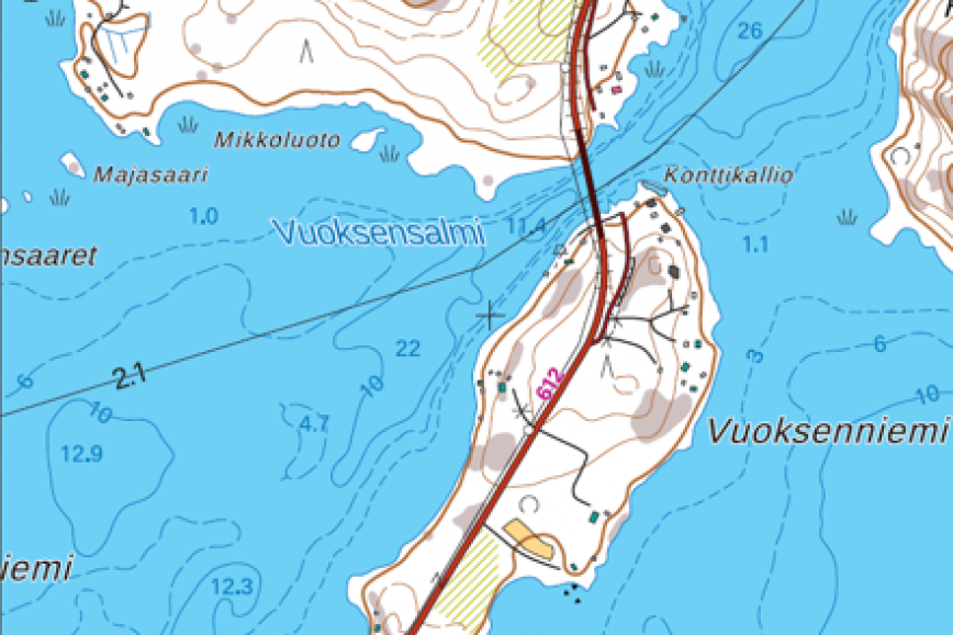
Topographic data © National Land Survey of Finland
Nautical chart data © Finnish Transport and Communications Agency Traficom
Depth data © Finnish Environment Institute
WARNING: Not for navigation.
Base maps of statistics
You can freely publish base maps of statistics. When base maps are used, their original source must be indicated (© National Land Survey of Finland).
- Further information on base maps of statistics (in Finnish).
Interface services
Check publication rights from service descriptions or agreements.
- Interface services for property data (in Finnish)
- Interface services for maps (in Finnish)
- Interface services for geospatial data (in Finnish)
Online services
The terms of publication and use of services are service-specific. Read more:
- MapSite
- Geodata portal Paikkatietoikkuna
- Old printed maps
- Karelian Maps
- Land Information Service (in Finnish)
Additional information
If you have any questions about publication rights, contact us by emailing asiakaspalvelu@maanmittauslaitos.fi.