

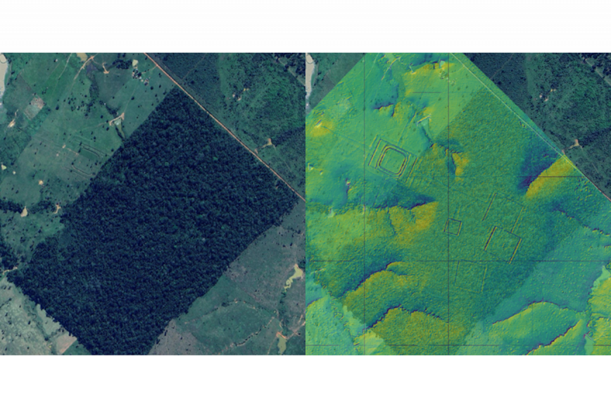
Laser scanning revealed a significant number of previously undetected geoglyphs, or earthworks associated with villages and ceremonial sites. The study was led by Professor Emeritus Martti Pärssinen from the University of Helsinki, and the results were published in the prestigious Nature journal on 29 July. The results indicate that up to a few million people lived on the southwestern Amazon just before and after the beginning of CE – five times the previous estimate. The results have attracted extensive international attention.
Terrain models revealed lost excavations
The study was carried out by laser scanning the area from an aircraft in parallel strips approximately one kilometre wide and 450 kilometres long at intervals of ten kilometres, after which terrain models were calculated for the areas. The Finnish Geospatial Research Institute (FGI) at the National Land Survey, which was responsible for the technical implementation, has been involved in the interpretation of laser scanning data, or point cloud research, for more than 25 years.
“Our local partner performed the scanning in accordance with the instructions we provided on how and at what altitudes the flights should be carried out. We then processed and analysed the huge data masses and carried out a sensitivity analysis to assess the reliability of the terrain model in detecting geoglyphs”, says Associate Professor Eetu Puttonen.
With the help of the terrain model and hillshading, the patterns on the ground surface were made visible. Finally, the research team’s archaeologists went through the material manually and calculated the size and location of the excavations. The results reveal man-made soil modifications in a way that is impossible to see from satellite images or from ground level.
Finnish expertise in forest research was helpful in this.
“Finland is a country of forests and we have extensive forest research expertise. We are able to choose the appropriate methods for researching different targets. With laser scanning, it is possible to digitize large geographical areas at once, which is also what we do in Finland's national laser scanning programme.”
National laser scanning data is used in Finland for producing terrain models, analysing flood risks and performing forest inventory, among other things. Researchers use it, for example, to study forest structure, the presence of berries and autonomous driving.
The same method could be used to explore other areas
Laser scanning in the rainforest had its challenges. It was not possible to distinguish the ground surface through the densest forest canopies, and the best results were obtained for sparse or treeless areas. In addition, research ethical considerations related to indigenous peoples had to be taken into account in the region.
“The use of laser scanning in archaeological research is not new, but it has not been utilised on this scale in the Amazon region before. Unexplored areas in other parts of the world could also be mapped this way”, notes Eetu Puttonen.
The study was carried out by Finnish personnel, but the funding came from a private US donor.
The study was conducted as a collaboration between the University of Helsinki, the University of Turku, the National Land Survey of Finland, Aarhus University and local actors. The project is coordinated by the Finnish Institute in Madrid and the Factum Foundation (Madrid).
The study is part of the UNITE Flagship exploring the interaction between forests, humans and machines.
Further information
Associate Professor Eetu Puttonen, +358 29 531 4868, firstname.lastname@maanmittauslaitos.fi
University of Helsinki press release
The Nature article is openly available here